Königswartha

Königswartha
Königswartha
Image illustrative de l'article Königswartha
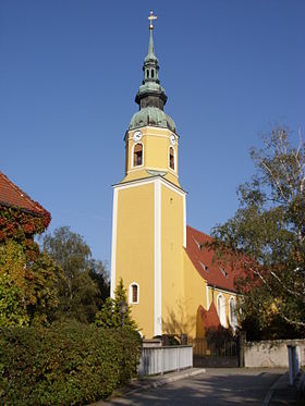
Vue de l'église du village (luthérienne-évangélique)
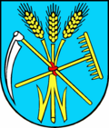
Blason de Königswartha
Germany location map.svg
Königswartha
Administration
Toponyme officiel
Pays Drapeau d'Allemagne Allemagne
Land Drapeau du Land de Saxe Saxe
District
(Regierungsbezirk)
district de Dresde
Arrondissement
(Landkreis)
Arrondissement de Bautzen
Code communal
(Gemeindeschlüssel)
Code postal
Indicatif téléphonique
Immatriculation
Politique
Bourgmestre
(Bürgermeister)
Georg Paschke
Partis au pouvoir CDU
Géographie
Coordonnées 51° 18′ 39″ N 14° 19′ 38″ E / 51.3108, 14.327251° 18′ 39″ Nord
       14° 19′ 38″ Est
/ 51.3108, 14.3272
  
Altitude (NN) 141 m
Superficie  km2
Démographie
Population 3 780 hab. (31 décembre 2010)
Densité 80 hab./km2

Königswartha (en haut-sorabe: Rakecy) est une commune de Saxe (Allemagne), située dans l'arrondissement de Bautzen, dans le district de Dresde. Sa population était de 3 780 habitants au 31 décembre 2010.

Sommaire

Municipalité

L'ancienne auberge d'Oppitz, photographie de Günter Rapp en 1987

Plusieurs petits villages ou hameaux, outre Königswartha (2 436 habitants), ont été intégrés à la commune. Il s'agit de

  • Caminau, 98 habitants
  • Commerau, 276 habitants
  • Entenschenke, 27 habitants
  • Eutrich, 86 habitants
  • Johnsdorf, 61 habitants
  • Neudorf, 91 habitants
  • Niesendorf, 40 habitants
  • Oppitz, 207 habitants
  • Truppen, 83 habitants
  • Wartha, 382 habitants

Géographie

La commune est traversée par la petite rivière Schwarzwasser, affluent de l'Elster Noire.

Histoire

L'endroit a été mentionné en 1350 pour la première fois par écrit sous le nom de Conigswarte en tant que petite ville ayant acquis ses privilèges de marché. Son nom dérive d'une tour de garde (Wartturm) construite pour surveiller les territoires du roi de Bohême. Elle surveillait en effet la route de Bautzen à Hoyerswerda.

Jusqu'au congrès de Vienne (1815), Königswartha était une ville frontière entre le royaume de Saxe et le royaume de Prusse auquel elle a finalement été intégrée. La frontière passait au nord du village. Deux bornes frontière restaurées en septembre 2008 sont visibles aujourd'hui sur la place du marché.

Königswartha comptait 1 119 habitants en 1884, dont 87% (969) étaient Sorabes.

Monuments

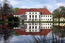
Vue du château de Königswartha
  • Église luthérienne-évangélique
  • Château de Königswartha (1780)

Articles connexes


Wikimedia Foundation. 2010.

Contenu soumis à la licence CC-BY-SA. Source : Article Königswartha de Wikipédia en français (auteurs)

Игры ⚽ Нужен реферат?

Regardez d'autres dictionnaires:

  • Königswartha — Königswartha, 1) Gerichtsamt im königlich sächsischen Kreisdirectionsbezirk Bautzen (Oberlausitz), mit 7267 Ew.; 2) Marktflecken u. Amtssitz darin, am Schwarzwasser, Schloß, Eisensteingruben; 900 Ew.; hier wurden den 19. Mai 1813 die Franzosen… …   Pierer's Universal-Lexikon

  • Königswartha — Königswartha, Flecken in der sächs. Kreis und Amtsh. Bautzen, am Schwarzwasser u. an der Staatsbahnlinie Bautzen K., hat eine evang. Kirche, ein Schloß, Blindenasyl, bedeutende Teichfischzucht (jährlich über 12,500 dz Karpfen), Dampfsägewerk und… …   Meyers Großes Konversations-Lexikon

  • Königswartha — Wappen Deutschlandkarte …   Deutsch Wikipedia

  • Königswartha — Infobox Ort in Deutschland name = Königswartha Rakecy image photo = Wappen = Koenigswartha Wappen.png lat deg = 51 |lat min = 19 lon deg = 14 |lon min = 20 Lageplan = Bundesland = Sachsen Regierungsbezirk = Dresden Landkreis = Bautzen Höhe = 141… …   Wikipedia

  • Konigswartha — Original name in latin Knigswartha Name in other language Konigswartha, Knigswartha State code DE Continent/City Europe/Berlin longitude 51.31028 latitude 14.32797 altitude 144 Population 3767 Date 2012 05 15 …   Cities with a population over 1000 database

  • Bahnstrecke Königswartha–Weißkollm — Königswartha–Abzw Weißkollm Kursbuchstrecke (DB): 234 (1999) Streckennummer: 6579 Streckenlänge: 12,96 km Spurweite: 1435 mm (Normalspur) Höchstgeschwindigkeit: 100 km/h L …   Deutsch Wikipedia

  • Truppen (Königswartha) — Truppen Trupin Gemeinde Königswartha Koordinaten …   Deutsch Wikipedia

  • Wartha (Königswartha) — Wartha Stróža Gemeinde Königswartha Koordinaten …   Deutsch Wikipedia

  • Oppitz (Königswartha) — Oppitz Psowje Gemeinde Königswartha Koordinaten …   Deutsch Wikipedia

  • Commerau (Königswartha) — Commerau Komorow Gemeinde Königswartha Koordinaten …   Deutsch Wikipedia

Share the article and excerpts

Direct link
Do a right-click on the link above
and select “Copy Link”