Kodisjoki

Kodisjoki
Kodisjoki (fi)
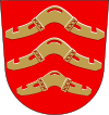
Blason de {{{PAGENAME}}}
Blason
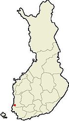
Carte de localisation de la municipalité de {{{PAGENAME}}}
Géographie
Pays Drapeau de Finlande Finlande
Province historique Satakunta
Province Finlande-Occidentale
Région Satakunta
Superficie
 · Totale 42,84 km2
 · Dont eau douce 2,08 km2 (5,1%)
Altitude
 · Maximale env. 50 m
 · Minimale 12 m
Démographie
Population (01/11/2006) 520 hab.
Densité 12,76  hab./km2
Langue(s) officielle(s) unilingue finnois
Administration
Fondée en 1896
Disparue en 1er janvier 2007
Raison fusion dans Rauma

Kodisjoki est une ancienne municipalité du sud-ouest de la Finlande, dans la province de Finlande occidentale et la région du Satakunta. C'était une des plus petites communes du pays et également la moins peuplée qui ne soit pas sur une île avant sa disparition par fusion dans Rauma le 1er janvier 2007, fusion approuvée en mars 2006 par le conseil municipal.

Ancien village de Laitila, elle est autonome depuis 1896. Elle est formée d'un territoire essentiellement plat et agricole entourant le petit village de Kodisjoki. L'église du village date de 1778.

La commune est bordée par les municipalités de Rauma au nord, Lappi au nord-est, et côté Finlande du Sud-Ouest par Pyhäranta à l'ouest et Laitila au sud.

Liens externes


Wikimedia Foundation. 2010.

Contenu soumis à la licence CC-BY-SA. Source : Article Kodisjoki de Wikipédia en français (auteurs)

Игры ⚽ Поможем решить контрольную работу

Regardez d'autres dictionnaires:

  • Kodisjoki — is a former municipality of Finland.It is located in the province of Western Finland and is part of the Satakunta region. The municipality has a population of 518 (2003) and covers an area of 42.84 km² of which 2.08 km² is water. The population… …   Wikipedia

  • Kodisjoki — Wappen der ehemaligen Gemeinde Kodisjoki Kodisjoki ist ein Ort und eine ehemalige Gemeinde in der südwestfinnischen Landschaft Satakunta, rund 15 km südöstlich der Hafenstadt Rauma. Die hölzerne Langkirche des Dorfes wurde 1906 nach Plänen von… …   Deutsch Wikipedia

  • Raumo — Rauman kaupunki Wappen Karte Basisdaten Staat …   Deutsch Wikipedia

  • Rauma, Finland — Infobox Settlement official name = Rauma native name = nickname = motto = Kyl Raum o ain Raum imagesize = image caption = image shield = Rauma.vaakuna.svg image dot dot x = 63 dot y = 175 dot map caption = Location of Rauma in Finland dot mapsize …   Wikipedia

  • List of Finnish municipalities by population — This is a list of the municipalities of Finland sorted by population as of 31st of December 2005:# Helsinki (Helsingfors) 560 905 {+0,3%} # Espoo (Esbo) 231 704 {+1,9%} # Tampere (Tammerfors) 204 337 {+0,7%} # Vantaa (Vanda) 187 281 {+1,0%} #… …   Wikipedia

  • List of Finnish municipalities by area — This is a list of the municipalities of Finland sorted by area as of 1st of January 2006:# 17333.38 km²: Inari (Enare) # 12415.26 km²: Sodankylä # 8391.54 km²: Enontekiö (Enontekis) # 8263.09 km²: Kittilä # 8017.20 km²: Rovaniemi # 6496.64 km²:… …   Wikipedia

  • Merikarvia —   Municipality   Merikarvian kunta …   Wikipedia

  • Nakkila —   Municipality   Nakkilan kunta Viikkala school in Nakkila …   Wikipedia

  • Noormarkku —   Former municipality   Noormarkun kunta …   Wikipedia

  • List of former municipalities of Finland — This is a list of the former municipalities of Finland.Contents: A B C D E F G H I J K L M N O P Q R S T U V W X Y Z Å Ä Ö NOTOC A *Ahlainen became part of Pori in 1972 *Aitolahti became part of Tampere in 1966 *Akaa was divided in 1946 between… …   Wikipedia

Share the article and excerpts

Direct link
Do a right-click on the link above
and select “Copy Link”