Inchmickery
- Inchmickery
-
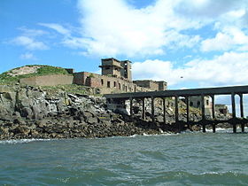
Inchmickery est une petite île du Firth of Forth en Écosse. Elle se trouve à environ un kilomètre et demi d'Édimbourg.
Son nom est d'origine écossaise, Innis nam Bhiocaire signifiant « île du vicaire », ce qui semble indiquer qu'il s'y trouvait autrefois un établissement ecclésiastique, comme sur l'île d'Inchcolm toute proche. Inchmickery est l'objet d'une charade bien connue dans le pays : "How many inches is the Forth?" (« combien de pouces fait le Firth of Forth ? »), jouant sur le mot 'Inch' (Innis), le mot gaélique pour « île » et 'inch', le « pouce », unité de mesure.
Inchmickery est une île étroite, d'à peine 100 mètres sur 200. Lors de la Seconde Guerre mondiale, elle fut utilisée comme base armée. Les structures militaires en béton donnaient de loin l'impression d'un navire de guerre. Bien qu'Inchmickery soit aujourd'hui inhabitée, la plupart de ses bâtiments de béton demeurent intacts. Le site a servi de décor au film Complicity, de Iain Banks (2001).
L'île est aujourd'hui une réserve de la RSPB. Elle est le lieu de nidification de plusieurs espèces comme l'eider à duvet, la sterne caugek, et la sterne de Dougall, cette dernière étant une espèce menacée.
Voir aussi
Articles connexes
Liens externes
Sur les autres projets Wikimedia :
Wikimedia Foundation.
2010.
Contenu soumis à la licence CC-BY-SA. Source : Article Inchmickery de Wikipédia en français (auteurs)
Regardez d'autres dictionnaires:
Inchmickery — is a small island in the Firth of Forth in Scotland. It is about a mile (1.6 km) north of Edinburgh.Its name comes from the Scottish Gaelic, Innis nam Bhiocaire , meaning Isle of the Vicar , implying that there may have been an old ecclesiastical … Wikipedia
Isle of May — Location … Wikipedia
Inchgarvie — (occasionally Inch Garvie ) is a small island in the Firth of Forth. Presently uninhabited, Inchgarvie has seen various inhabitants over the years, and is known to have been inhabited at least as early as the late 15th century.The name comes from … Wikipedia
British anti-invasion preparations of World War II — entailed a large scale division of military and civilian mobilization in response to the threat of invasion by German armed forces in 1940 and 1941. The army needed to recover from the defeat of the British Expeditionary Force in France, and 1.5… … Wikipedia
Islands of the Forth — The Islands of the Firth of Forth are a minor island group, lying between Fife and the Lothians, in east Scotland. There are few islands off eastern Scotland, and this group comprises the majority.They include:* Bass Rock * Craigleith *… … Wikipedia
Organisation défensive du Royaume-Uni pendant la Seconde Guerre mondiale — Gros plan sur l embrasure d un emplacement de tir abrité. L organisation défensive du Royaume Uni durant la Seconde Guerre mondiale a entraîné une mobilisation des militaires et des civils sur une très grande échelle en réponse à la menace d… … Wikipédia en Français
Firth — is the Lowland Scots word used to denote various coastal waters in Scotland. It is usually a large sea bay, which may be part of an estuary, or just an inlet, or even a strait. It is cognate to fjord (both from Proto Germanic *ferþuz) which has a … Wikipedia
Firth of Forth — The Firth of Forth (Scottish Gaelic: Linne Foirthe ) is the estuary or firth of Scotland s River Forth, where it flows into the North Sea between Fife to the north, and West Lothian, the City of Edinburgh, and East Lothian to the south.Geography… … Wikipedia
Inchcolm — Infobox Scottish island | latitude=56.03 longitude= 3.30 GridReference=NT189827 celtic name= Innis Choluim norse name= meaning of name=Island of St Columba area= 9 ha area rank= highest elevation= 34 m Population=2 population rank= 88= main… … Wikipedia
Craigleith — This article is about the island in the Firth of Forth. For the suburb of Edinburgh, see Craigleith, Edinburgh … Wikipedia

 Royaume-Uni
 Royaume-Uni
