Gauri Sankar
- Gauri Sankar
-
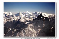
Le Gauri Sankar est le deuxième plus haut sommet du Rolwaling Himal, derrière le Melungtse (7 181 mètres). Son nom signifie en sanskrit « la déesse et ses époux ». Il est aussi appelé Gaurishankar ou Jomo Tseringma.
Ascensions
- 1965-1979 - Le sommet est officiellement fermé.
- 1979 - Première ascension par une expédition américano-népalaise.
Wikimedia Foundation.
2010.
Contenu soumis à la licence CC-BY-SA. Source : Article Gauri Sankar de Wikipédia en français (auteurs)
Regardez d'autres dictionnaires:
Gauri Sankar — (vorne rechts) Höhe 7.134 m … Deutsch Wikipedia
Gauri Sankar — Infobox Mountain Name = Gauri Sankar Photo = IMG 09641.jpg Caption = Gauri Shankar (right) Elevation = 7,134 metres (23,405 feet) Location = Nepal China (Tibet) Range = Rolwaling Himal Prominence = Coordinates =… … Wikipedia
Gaurisankar — f1 Gauri Sankar Höhe 7.134 m Lage Nepal China (Tibet) Gebirge Himalaya, Rolwaling Himal … Deutsch Wikipedia
Gaurishankar — f1 Gauri Sankar Höhe 7.134 m Lage Nepal China (Tibet) Gebirge Himalaya, Rolwaling Himal … Deutsch Wikipedia
Liste der Berge oder Erhebungen in Nepal — In dieser Liste werden die höchsten Berge und Erhebungen Nepals auf dem Staatsgebiet von Nepal geführt, enthalten sind alle Erhebungen mit einer sogenannten Schartenhöhe von mindestens 150 Metern. Die Liste ist vollständig in dem Bereich von 6900 … Deutsch Wikipedia
Village development committee — Nepal This article is part of the series: Politics and government of Nepal Government … Wikipedia
The Gourishankar — Жанры прогрессивный рок арт рок эклектик прог Годы 2002 наши дни Страна … Википедия
Charikot — Municipality Landscape near Charikot; from North of the town … Wikipedia
Melungtse — (right) and Gauri Shankar (left) Elevation 7,181 m (23,560 ft) … Wikipedia
Himalayas — Geobox|Range name=Himalayas image caption=The north face of Mount Everest as seen from the path to the base camp in Tibet country=Bhutan| country1=Tibet (invaded by PRC) | country2=India| country3=Nepal| country4=Pakistan| country5 = Burma |… … Wikipedia

 Népal
Népal Chine
Chine


