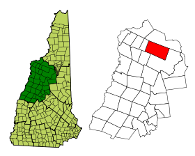
Franconia (New Hampshire)
Contenu soumis à la licence CC-BY-SA. Source : Article Franconia (New Hampshire) de Wikipédia en français (auteurs)
Regardez d'autres dictionnaires:
Franconia, New Hampshire — Infobox Settlement official name = Franconia, New Hampshire nickname = motto = image imagesize = image caption = imagesize = image caption = mapsize = 250px map caption = Location in Grafton County, New Hampshire settlement type = Town mapsize1 … Wikipedia
Owl's Head (Franconia, New Hampshire) — Owl s Head Owl s Head from Bondcliff, with Franconia Ridge behind Elevation 4,025 ft (1,227 m) … Wikipedia
New Hampshire locations by per capita income — New Hampshire is the seventh richest state in the United States of America, with a per capita income of $23,844 (2000) and a personal per capita income of $34,702 (2003). New Hampshire counties ranked by per capita income There are ten counties… … Wikipedia
New Hampshire communities by population — The 234 incorporated cities and towns in the New Hampshire ranked by population, from the 2010 United States Census. Location of New Hampshire in the United States … Wikipedia
New Hampshire communities by household income — The 234 incorporated cities and towns in the New Hampshire ranked by household income, calculated in 2006, and published in 2007. Rank Community Median Household Income 1 Windham, New Hampshire $94,794 2 Hollis, New Hampshire $92,847 3 … Wikipedia
New Hampshire Route 117 — Route information Maintained by NHDOT Length: 8.12 mi … Wikipedia
New Hampshire Route 142 — Route information Maintained by NHDOT Length: 19.71 mi … Wikipedia
New Hampshire — New Hampshirite /hamp sheuh ruyt /, New Hampshireman. /hamp sheuhr, shear/ 1. a state in the NE United States. 920,610; 9304 sq. mi. (24,100 sq. km). Cap.: Concord. Abbr.: NH (for use with zip code), N.H. 2. one of an American breed of chestnut… … Universalium
New Hampshire Route 141 — Butterhill Road Route information Maintained by NHDOT Length … Wikipedia
New Hampshire Outing Club — 200px Established 1911 Location Durham, New Hampshire, USA Website www.unh.edu/nhoc … Wikipedia
 Pour les articles homonymes, voir Franconia.
 États-Unis
 New Hampshire


