Castlereagh Highway
- Castlereagh Highway
-

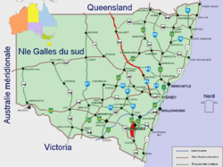
La Castlereagh Highway en rouge.
La Castlereagh Highway est un axe routier long de 781 km en Nouvelle-Galles du Sud, en Australie, s'étendant sur quelques kilomètres dans le Queensland. Elle doit prendre le nom officiel de B55.
Orientée sud-est vers nord ouest, elle démarre de la Great Western Highway à sa sortie de Lithgow et va s'achever à la ville de St George au Queensland en rejoignant la Carnarvon Highway après avoir franchi la frontière à Hebel.
Elle traverse les villes de Capertee, Ilford, Mudgee, Gulgong, Dunedoo, Gilgandra, Coonamble, Walgett, Lightning Ridge, Hebel, Dirranbandi.
Elle croise la Golden Highway à 8 km à l'est de Dunedoo. La Bathurst-Ilford Road démarre d'Ilford, tandis que la Bylong Valley Way en part 2 km plus au nord.
Wikimedia Foundation.
2010.
Contenu soumis à la licence CC-BY-SA. Source : Article Castlereagh Highway de Wikipédia en français (auteurs)
Regardez d'autres dictionnaires:
Castlereagh Highway — Straßenverlauf Dick O Brien Bridge (1991) über den … Deutsch Wikipedia
Castlereagh Highway — Infobox Australian Road road name = Castlereagh Highway route route route photo = caption = Proposed .] length = 781 direction = North South start = finish = est = through = Dirranbandi, Hebel, Walgett, Coonamble, Gulargambone, Gilgandra,… … Wikipedia
Castlereagh River (New South Wales) — Castlereagh River Castlereagh River vom Castlereagh Highway südlich von WalgettVorlage:Infobox Fluss/KARTE fehlt … Deutsch Wikipedia
Castlereagh (disambiguation) — Castlereagh may refer to: *Robert Stewart, Viscount Castlereagh (1769 ndash;1822), an Anglo Irish politician *Castlereagh Borough Council, a local council near Belfast, Northern Ireland *Castlereagh River, a river in northern New South Wales,… … Wikipedia
Castlereagh (Begriffsklärung) — Castlereagh ist die Bezeichnung für: der nordirische District Castlereagh bei Belfast den anglo irischen Politiker Robert Stewart, Viscount Castlereagh (1769–1822) die australische Gemeinde Castlereagh, ein Vorort von Sydney beide Castlereagh… … Deutsch Wikipedia
Oxley Highway — Route information Length … Wikipedia
New England Highway — New England Highway … Wikipedia
Mitchell Highway — Proposed … Wikipedia
Newell Highway — Proposed to replace … Wikipedia
Carnarvon Highway — Infobox Australian Road road name = Carnarvon Highway Carnarvon Developmental Road route route route photo = caption = Formerly length = 696 direction = North South start = finish = est = through = Injune, Roma, Surat, St George, Mungindi route … Wikipedia

