Watson Lake (Yukon)
- Watson Lake (Yukon)
-

Pour les articles homonymes, voir
Watson,
Lake et Watson Lake.
60°07′N 128°48′W / 60.117, -128.8
Watson Lake est une localité du Yukon au Canada, située à l'intersection de la Route de l'Alaska et de la Robert Campbell Highway, à la frontière entre le Yukon et la Colombie-Britannique, près de la rivière Liard. Sa population était de 1547 habitants en 2004.
Watson Lake est un centre important de sylviculture au Yukon et a connu une industrie minière, dans l'extraction de l'amiante et du tungstène des monts Mackenzie dans les Territoires du Nord-Ouest.

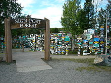
La forêt de panneaux à Watson Lake
Un centre d'observation et d'étude des aurores boréales s'y trouve[1] ainsi qu'une forêt de panneaux de signalisation créée en 1942 par les personnels militaires qui travaillaient à la construction de la Route de l'Alaska, lesquels avaient pris l'habitude d'y mettre chacun un panneau indiquant la localité d'où ils venaient. La tradition se poursuivant actuellement, il y en a actuellement 76000[2].
Watson Lake bénéficie d'un climat subarctique avec une moyenne de température de 21 °C en juillet et de -29 °C en janvier. La plus haute température relevée étant de 34 °C en mai 1983 et la plus basse de -59 °C en janvier 1947.

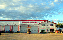
Une activité à Watson Lake
La ville et sa voisine Upper Liard, font partie de la Liard River First Nation, membres du conseil du peuple Kaska[3].
Articles connexes
Notes et références
Lien externe
|
Liste des capitales provinciales et territoriales du Canada |
| Capitales provinciales |
Victoria, CB · Edmonton, AB · Régina, SK · Winnipeg, MB · Toronto, ON · Québec, QC · Fredericton, NB · Halifax, NÉ · Charlottetown, IPE · St. John's, TNL |
 |
| Capitales Territoriales |
Whitehorse, YK · Yellowknife, TNO · Iqaluit, NU |
| Capitale Nationale : Ottawa |
Wikimedia Foundation.
2010.
Contenu soumis à la licence CC-BY-SA. Source : Article Watson Lake (Yukon) de Wikipédia en français (auteurs)
Regardez d'autres dictionnaires:
Watson Lake, Yukon — Watson Lake is a town at historical mile 635 on the Alaska Highway in the southeastern Yukon close to the British Columbia border. Population in December 2004 was 1,547 (Yukon Bureau of Statistics).Watson Lake is near the Liard River, at the… … Wikipedia
Watson Lake — Watson Lake, Yukon Watson Lake Sign Post Forest … Deutsch Wikipedia
Watson Lake — may refer to:* Watson Lake, Yukon * Watson Lake (Arizona) * Watson Lake (California) * Watson Lake (North Carolina) … Wikipedia
Watson Lake Airport — Infobox Airport name = Watson Lake Airport IATA = YQH ICAO = CYQH type = Public owner = operator = Government of Yukon city served = location = Watson Lake, Yukon elevation f = 2,225 elevation m = 687 coordinates =… … Wikipedia
Watson Lake Water Aerodrome — is located convert|4|NM|abbr=on|lk=in west of Watson Lake, Yukon, Canada.ee also*Watson Lake AirportReferences … Wikipedia
Watson Lake (electoral district) — Watson Lake is an electoral district which returns a member (known as an MLA) to the Legislative Assembly of the Yukon Territory in Canada. The current MLA is Dennis Fentie, who is the leader of the Yukon Party and the Premier of Yukon. He had… … Wikipedia
Watson Lake — ▪ village, Yukon Territory, Canada community, southern Yukon Territory (Yukon), Canada. It lies along a small lake on the border with British Columbia. It originated as a 19th century trading post and was named after Frank Watson, a pioneer … Universalium
Marsh Lake, Yukon — Marsh Lake is an unincorporated bedroom community on the Alaska Highway on the shores of Marsh Lake southeast of Whitehorse in Canada s Yukon. The area was organized in 2001, as a local area council to help the residents with some form of… … Wikipedia
Marsh Lake (Yukon) — Pour les articles homonymes, voir Marsh. 60°31′00″N 134°19′59″O / … Wikipédia en Français
Alligator Lake (Yukon) — Alligator Lake Satellitenaufnahme Geographische Lage Yukon, südwestlich von Whitehorse Abfluss Two Horse Creek → Watson River → … Deutsch Wikipedia
 Watson Lake sur la Route de l'Alaska


