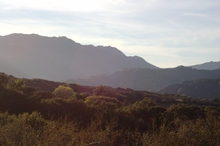
Topanga Canyon

Topanga Canyon

34° 06′ 11″ N 118° 36′ 18″ W / 34.103, -118.605

Topanga Canyon

Topanga est un canyon dans la région de Los Angeles, en Californie dans les montagnes de Santa Monica. Le nom lui a été donné par les amérindiens qui occupaient la région, les Tongya[1] et signifierait « le lieu au-dessus ».

Dans les années 1960, le secteur attira beaucoup d'artistes, dont Neil Young, Woody Guthrie et d'autres. Charles Manson et sa « famille » occupèrent les lieux également avant les meurtres. Le canyon est resté une enclave pour les artistes et les musiciens de toutes sortes.

Une célèbre discothèque, le Topanga Corral, recevait à cette époque de nombreuses stars de la musique, comme Canned Heat, Derroll Adams, Emmylou Harris, Crazy Horse, Ramblin' Jack Elliott

La chanson de Billy Joel "Getting Closer" de 1986 album évoque le canyon : I'm a mark for every shyster from Topanga to Berlin.
John Phillips lui a dédié la chanson "Topanga canyon" sur son album "John, the wolfking of L.A.".

Notes et références

  1. Bright, W. (1998). 1500 California Place Names 3rd Ed. UC Press. pg 155.

Liens externes


Wikimedia Foundation. 2010.

Contenu soumis à la licence CC-BY-SA. Source : Article Topanga Canyon de Wikipédia en français (auteurs)

Игры ⚽ Нужен реферат?

Regardez d'autres dictionnaires:

  • Topanga Canyon Inn Bed and Breakfast — (Topanga,США) Категория отеля: 3 звездочный отель Адрес: 20310 …   Каталог отелей

  • Topanga, California — Topanga is an unincorporated area in western Los Angeles County, California, USA. It is located in the Santa Monica Mountains and occupies Topanga Canyon. Topanga is 12,748 acres (52 km²) in size, and is bounded on three sides by State Park or… …   Wikipedia

  • Topanga — ist ein Landstrich in den Santa Monica Mountains im südlichen Kalifornien, USA. Die Einwohnerzahl beträgt ca. 12.000, die Fläche ca. 52 km². Im Süden grenzt das Gebiet an den Pazifik, im Westen an Malibu und im Osten an Pacific Palisades. Topanga …   Deutsch Wikipedia

  • Topanga State Park — is a California state park located in Los Angeles County. It is located adjacent to the unincorporated community of Topanga, California, within the city of Los Angeles, California. Covering 11,000 acres (45 km²) it is the largest state park… …   Wikipedia

  • Canyon News — Infobox Newspaper name = Canyon news caption = Front page from January 21, 2007 type = weekly newspaper format = Broadsheet foundation = August, 2001 headquarters = 260 beverly Dr Beverly Hills, California 90212 USA publisher = Glen Kelly editor …   Wikipedia

  • Westfield Topanga — infobox shopping mall shopping mall name = Westfield Topanga image width = 250 caption = location = Canoga Park, Los Angeles, California, USA opening date = February 10, 1964 developer = May Centers, Inc. manager = The Westfield Group owner = The …   Wikipedia

  • Upper Las Virgenes Canyon Open Space Preserve — The Upper Las Virgenes Canyon Open Space Preserve is a large open space nature preserve owned and operated by the Santa Monica Mountains Conservancy spanning nearly 3,000 acres (12 km²) in western Los Angeles County and eastern Ventura County.… …   Wikipedia

  • Westfield Topanga — Coordenadas: 34°11′26″N 118°36′11″W / 34.19047, 118.603163 …   Wikipedia Español

  • Laurel Canyon, Los Angeles, California — Laurel Canyon is a canyon neighborhood of Los Angeles, California. It was first developed in the 1910s, and became a part of the city of Los Angeles in 1923 (prior to then, it was an unincorporated part of Los Angeles County). [cite encyclopedia… …   Wikipedia

  • Rustic Canyon, Los Angeles, California — Rustic Canyon is a suburban residential neighborhood of Los Angeles, California, on the west side of the city, encompassing the part of Santa Monica Canyon located within the city limits of Los Angeles, bordered approximately by Sunset Boulevard… …   Wikipedia

Share the article and excerpts

Direct link
Do a right-click on the link above
and select “Copy Link”