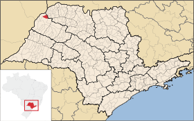
Suzanápolis
Contenu soumis à la licence CC-BY-SA. Source : Article Suzanápolis de Wikipédia en français (auteurs)
Regardez d'autres dictionnaires:
Suzanápolis — is a municipality in the state of São Paulo in Brazil. The population in 2004 was 2,868 and the area is 328.84 km². The elevation is 350 m … Wikipedia
Suzanapolis — Admin ASC 2 Code Orig. name Suzanápolis Country and Admin Code BR.27.3552551 BR … World countries Adminstrative division ASC I-II
Municipios de São Paulo — Contenido 1 Mesoregiones y Microregiones 1.1 Mesorregión de Araçatuba 1.1.1 Microrregión de Andradina 1.1.2 Microrregión de Araçatuba … Wikipedia Español
Муниципалитеты штата Сан-Паулу — … Википедия
Сузанаполис — Муниципалитет Сузанаполис Suzanápolis Страна БразилияБразилия … Википедия
List of municipalities in São Paulo — Municipalities of São Paulo This is a list of the municipalities in the state of São Paulo (SP), Brazil. Mesoregion Microregion Municipality Araçatuba Andradina Andradina … Wikipedia
Mesoregion of Araçatuba — Mesoregion Location of the Mesoregion of Araçatuba … Wikipedia
Mirandópolis — Coordinates: 21°08′01″S 51°06′06″W / 21.13361°S 51.10167°W / 21.13361; 51.10167 Mirandópolis A região onde está localizada a … Wikipedia
Murutinga do Sul — Coordinates: 20°59′26″S 51°16′29″W / 20.99056°S 51.27472°W / 20.99056; 51.27472 Murutinga do Sul is a municipality in the stat … Wikipedia
Nova Independência — Coordinates: 21°06′14″S 51°29′24″W / 21.10389°S 51.49°W / 21.10389; 51.49 Nova Independência (lit., New … Wikipedia
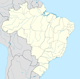
 Brésil
 São Paulo