Sgor an Lochain Uaine
- Sgor an Lochain Uaine
-
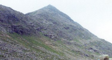
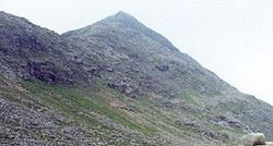
Le Sgòr an Lochain Uaine est une montagne du Cairngorms, en Écosse. C'est le cinquième plus haut sommet d'Écosse et du Royaume-Uni avec ses 1 258 m d'altitude. C'est le troisième plus haut sommet du massif de Cairngorms, se trouvant entre le Braeriach et le Cairn Toul sur la face est du passage de Lairig Ghru. Il a été élevé au statut de munro par le Scottish Mountaineering Club lors de la révision de 1997.

Cairn Toul (à gauche), Sgor an Lochain Uaine (tout à fait à droite).
Sgòr an Lochain Uaine est une montagne isolée, disposant d'un long itinéraire d'ascension vers le sommet. Elle est généralement escaladée à la suite d'autres sommets de la région, comme le Cairn Toul et le Devil's Point au sud, Braeriach au nord. La majeure partie de la voie sud à l'avantage de pouvoir être parcourue en VTT.
Toponymie
La montagne doit son nom à An Lochan Uaine, le Lochan situé dans le cirque au nord-est du sommet. Il est parfois connu comme The Angel's Peak, sur certaines cartes, mais il s'agit là d'une invention du XIXe siècle pour créer un antagoniste au proche The Devil's Point[1].
Références
Wikimedia Foundation.
2010.
Contenu soumis à la licence CC-BY-SA. Source : Article Sgor an Lochain Uaine de Wikipédia en français (auteurs)
Regardez d'autres dictionnaires:
Sgor an Lochain Uaine — Der Gipfel des Sgor an Lochain Uaine, vom Kar An Garbh Coire aus gesehen. Höhe … Deutsch Wikipedia
Sgor an Lochain Uaine — Infobox Mountain Name = Sgor an Lochain Uaine Photo = Sgor an lochan uaine.jpg Caption = Sgor an Lochain Uaine from the entrance to An Garbh Coire Elevation = 1258 m (4127 ft) Location = Cairngorms, Scotland Range = Prominence = 118 m Coordinates … Wikipedia
List of Munros — Infobox Mountain Name = Sections of Munro s tables Photo = Scotland sections of Munro s tables.png Caption = The approximate divisions of Scotland used in Munro s tables Elevation = over 3,000 feet (914.4 metres) Location = SCO Range = Prominence … Wikipedia
The Devil's Point — Not to be confused with Devil s Point, Devon. The Devil s Point Bod an Deamhain Elevatio … Wikipedia
Mountains and hills of Scotland — Scotland is the most mountainous country in the United Kingdom. The area north and west of the Highland Boundary Fault is known as the Highlands, and contains the country s main mountain ranges. Scotland s mountain ranges, in a rough north to… … Wikipedia
Derry Cairngorm — seen from Càrn a Mhàim, 3.5 km to the SW. The Sròn Riach ridge descending from Ben Macdui is in the foreground … Wikipedia
Cairn Toul — Vue du Cairn Toul depuis le Braeriach, avec le Lochan Uaine. Géographie Altitude 1 291 m Massif … Wikipédia en Français
Cairn Toul — Infobox Mountain Name = Cairn Toul Photo = Cairn toul.jpg Caption = Cairn Toul from Braeriach, with Lochan Uaine Elevation = 1291 m (4236 ft) Location = Cairngorms, Scotland Range = Prominence = c. 166 m Topographic OS Landrangers 36, 43 Grid ref … Wikipedia
Càrn a' Mhàim — from Ben Macdhui. Elevation 1,037 m (3,402 ft) … Wikipedia
Cairngorms — This article is about the Scottish mountain range. For other uses, see Cairngorm. The Cairngorms are a mountain range in the eastern Highlands of Scotland closely associated with the mountain of the same name Cairn Gorm. The Cairngorms from Càrn… … Wikipedia
 Royaume-Uni
 Écosse