Cairn Toul
- Cairn Toul
-
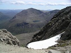
Cairn Toul (du gaélique Càrn an t-Sabhail, « colline de la grange ») est le quatrième sommet le plus élevé d'Écosse, derrière le Ben Nevis, le Ben Macdui et le Braeriach. C'est le second plus haut sommet dans l'Ouest du massif de Cairngorms, lié par un col à environ 1 125 m au-dessus du niveau de la mer à Braeriach.
Cairn Toul est souvent gravi avec d'autres sommets. Au sud on peut le combiner avec The Devil's Point, 2,5 km au sud-est. Il peut également être gravi par le nord avec le Braeriach et le Sgor an Lochain Uaine. Chacune de ses voies est longue, mesurant une quinzaine de kilomètres.
La montagne peut également être gravie par l'ouest, en partant d'Achlean dans le Glen Feshie.
Wikimedia Foundation.
2010.
Contenu soumis à la licence CC-BY-SA. Source : Article Cairn Toul de Wikipédia en français (auteurs)
Regardez d'autres dictionnaires:
Cairn Toul — Blick auf den Cairn Toul vom Braeriach. Höhe 1.291 … Deutsch Wikipedia
Cairn Toul — Infobox Mountain Name = Cairn Toul Photo = Cairn toul.jpg Caption = Cairn Toul from Braeriach, with Lochan Uaine Elevation = 1291 m (4236 ft) Location = Cairngorms, Scotland Range = Prominence = c. 166 m Topographic OS Landrangers 36, 43 Grid ref … Wikipedia
Cairn Toul — Sp Kèrn Tùlas Ap Cairn Toul angliškai, geliškai (škotiškai) L k. Jungtinėje Karalystėje (Škotijoje) … Pasaulio vietovardžiai. Internetinė duomenų bazė
Cairn (disambiguation) — A cairn is an artificial pile of stones, often in a conical form.Cairn may also refer to:* Cairn Terrier * Cairn Magazine * Cairn Energy * Cairn Hill * Carn Clonhugh * Cairn O Mounth * Cairn Toul * Cairnryan * Cairn Valley Light Railway * Cairn… … Wikipedia
The Devil's Point — Not to be confused with Devil s Point, Devon. The Devil s Point Bod an Deamhain Elevatio … Wikipedia
Càrn a' Mhàim — from Ben Macdhui. Elevation 1,037 m (3,402 ft) … Wikipedia
Corrour Bothy — (21AUG07) Corrour Bothy is a simple stone building on Mar Lodge Estate, Aberdeenshire, Scotland. It is located below Coire Odhar between The Devil s Point and Cairn Toul on the western side of the River Dee in the Lairig Ghru. The bothy is a… … Wikipedia
Sgor an Lochain Uaine — Sgòr an Lochain Uaine depuis l entrée de An Garbh Coire. Géographie Altitude 1 258 m Massif … Wikipédia en Français
Mountains and hills of Scotland — Scotland is the most mountainous country in the United Kingdom. The area north and west of the Highland Boundary Fault is known as the Highlands, and contains the country s main mountain ranges. Scotland s mountain ranges, in a rough north to… … Wikipedia
Cairngorms — This article is about the Scottish mountain range. For other uses, see Cairngorm. The Cairngorms are a mountain range in the eastern Highlands of Scotland closely associated with the mountain of the same name Cairn Gorm. The Cairngorms from Càrn… … Wikipedia
 Royaume-Uni
 Écosse