Pen y Gaer
- Pen y Gaer
-
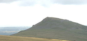
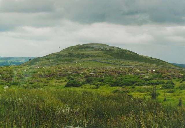
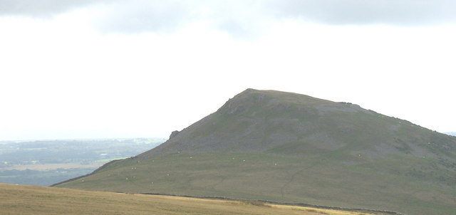
Pen y Gaer (Pen-y-gaer en gallois) est une colline fortifiée de type castrum située près du village de Llanbedr y Cennin dans le county borough de Conwy, au pays de Galles. Ses deux fortifications remontent à l'Âge de bronze. Les fondations de douze huttes sont encore visibles[2].
Le site est probablement abandonné aux alentours de l'an 130, en même temps que plusieurs autres places fortes de la région : Loughor, Neath, Pen y Darren, Gelligaer et Caerphilly[3].
Notes et références
Wikimedia Foundation.
2010.
Contenu soumis à la licence CC-BY-SA. Source : Article Pen y Gaer de Wikipédia en français (auteurs)
Regardez d'autres dictionnaires:
Pen Dinas — and the Wellington Monument Pen Dinas is the name of a hill south of Aberystwyth on the coast of Ceredigion, Wales, upon which an extensive Iron Age hill fort is situated. The name is more correctly Dinas Maelor , this could be translated into… … Wikipedia
Pen-y-garn, Ceredigion — Infobox UK place official name=Pen y garn static static image caption=Pen y garn, looking south towards Bow Street country=Wales population=1,888 [Total population of Tirymynach (cite web|url=http://neighbourhood.statistics.gov.uk/dissemination/Le… … Wikipedia
Moel y Gaer, Rhosesmor — For other places with the same name, see Moel y Gaer. Remains of the rampart of Moel y Gaer Moel y Gaer (Welsh for bald hill of the fortress ) is a prehistoric hill fort located on a summit of Halkyn Mountain, overlooking the village of Rhosesmor … Wikipedia
Conwy — This article is about the town. For other uses, see Conwy (disambiguation). Coordinates: 53°17′N 3°50′W / 53.28°N 3.83°W / 53.28; 3.83 … Wikipedia
River Conwy — Conwy (Afon Conwy) River Boats in the river estuary at Conwy … Wikipedia
Dolgarrog — is a small village in the Conwy County Borough in North Wales situated between Llanrwst and Conwy, very close to the Conwy River. The village is well known for its industrial history since the 18th century and the Eigiau dam disaster, which… … Wikipedia
Tal-y-bont, Conwy — Tal y Bont is a small village in Conwy county borough, Wales. It lies in the Conwy valley in North Wales, west of the River Conwy, on the B5106 road, six miles from Conwy to the north, and six miles from Llanrwst to the south.It lies adjacent to… … Wikipedia
Maenan — is a rural community in Conwy, Wales, located approximately 4 miles to the north of Llanrwst and 3 miles to the south of the village of Eglwysbach. The population of the area is approximately 300 people, and more than 75% of the population are… … Wikipedia
Burgwallanlage — Echimăuţi, Moldawien: Modell der bronzezeitlichen Ringwallanlage Als Wallburg (Schanze, Spitzwall) werden im deutschsprachigen Raum Wallanlagen aus dem frühen Mittelalter bezeichnet, also Burganlagen, Ringwälle, nicht jedoch Anlagen aus ur und… … Deutsch Wikipedia
Hillfort — Der Zugang von Dunadd Hillfort Hillfort ist die Bezeichnung für umwallte Areale, die auf Hügeln liegen. Hillforts sind in etwa runde, zumeist aber unregelmäßig der Geomorphologie der Landschaft angepasste Wall und Grabenanlagen. Halbrunde, an… … Deutsch Wikipedia

 Royaume-Uni
 Pays de Galles