Ohanavan
- Ohanavan
-
40° 20′ 45″ N 44° 22′ 59″ E / 40.345833, 44.383056
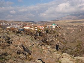
Ohanavan (en arménien Օհանավան) est une communauté rurale du marz d'Aragatsotn, en Arménie. Elle compte 2 402 habitants en 2009[2].
Le monastère de Hovhannavank est situé non loin[3].
Notes et références
- ↑ (hy+en) Central Electoral Commission of the Republic of Armenia. Consulté le 24 janvier 2011.
Pour obtenir la page en anglais, cliquez sur le drapeau arménien en haut à gauche, et sélectionnez « English » ; ensuite, dans le menu vertical de gauche, cliquez sur « Local », sélectionnez le
marz pertinent, puis la dernière élection correspondant à la communauté voulue.
- ↑ (en) ArmStat, Marzes of the Republic of Armenia in figures, « RA Aragatsotn Marz », 2009. Consulté le 19 novembre 2009.
- ↑ (en) Brady Kiesling, Rediscovering Armenia, 2000, p. 21 [lire en ligne (page consultée le 25 mars 2010)] .
Sur les autres projets Wikimedia :
Catégorie :
- Communauté rurale de l'Aragatsotn
Wikimedia Foundation.
2010.
Contenu soumis à la licence CC-BY-SA. Source : Article Ohanavan de Wikipédia en français (auteurs)
Regardez d'autres dictionnaires:
Ohanavan — Coordinates: 40°20′32″N 44°23′11″E / 40.34222°N 44.38639°E / 40.34222; 44.38639 … Wikipedia
Hovhannavank Monastery — Hovhannavank ( hy. Հովհաննավանք) is an Armenian Apostolic Church monastery located in the village of Ohanavan at the top of a steep gorge cut by the Kasagh river in the Aragatsotn Province ( marz ) of the Republic of Armenia. The monastery s… … Wikipedia
Yerevan — For other uses, see Yerevan (disambiguation). Coordinates: 40°11′00″N 44°31′00″E … Wikipedia
Saint Mesrob — St. Mesrop Mashtots Statue of Saint Mesrop Mashtots, founder of the Armenian alphabet, at the Matenadaran Institute of Ancient Manuscripts in Yerevan, Armenia. The original letters (i.e. only uppercase) in their original shapes can be seen on the … Wikipedia
Oshakan — This article is about a town in Armenia. For the city in Japan, see Osaka. Oshakan Օշական Oshakan as seen from the western side of Didikond Hill … Wikipedia
Aparan — This article is about the town. For the Malayalam film, see Aparan (film). Aparan Panorama of Aparan with Mount Aragats on the right … Wikipedia
Nor Hachn — Coordinates: 40°18′07″N 44°34′59″E / 40.30194°N 44.58306°E / 40.30194; 44.58306 … Wikipedia
Alagyaz — For other places with the same name, see Alagyaz (disambiguation). Coordinates: 40°40′53″N 44°17′25″E / 40.68139°N 44.29028°E / 40.68139; 44.29028 … Wikipedia
Avshen — Coordinates: 40°43′33″N 44°17′30″E / 40.72583°N 44.29167°E / 40.72583; 44.29167 … Wikipedia
Chknagh — Coordinates: 40°35′03″N 44°26′02″E / 40.58417°N 44.43389°E / 40.58417; 44.43389 … Wikipedia
 Arménie


