Glacier Petermann

Glacier Petermann
Glacier Petermann
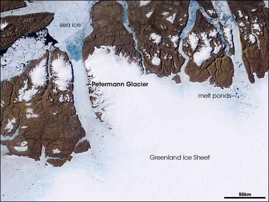
Vue satellite du glacier Petermann

Latitude
Longitude
80° 30′ Nord
       59° 30′ Ouest
/ 80.5, -59.5
80° 30′ N 59° 30′ W / 80.5, -59.5 
Pays Drapeau du Danemark Danemark
Province autonome Drapeau du Groenland Groenland
Municipalité Qaasuitsup
Type Glacier de vallée,
glacier côtier
Longueur maximale 70 km
Superficie 1 300 km2
Altitude du front glaciaire 0 m

Géolocalisation sur la carte : Groenland

(Voir situation sur carte : Groenland)
Glacier Petermann

Le glacier Petermann est un glacier côtier situé au nord-ouest du Groenland à l'est du détroit de Nares[1]. Il est relié à l'Inlandsis du Groenland et se jette dans l'océan Arctique.

Le glacier possède la plus grande langue glaciaire de l'hémisphère nord. D'importants vêlages se produisent mais, le 5 août 2010, grâce à une observation (MODIS) du satellite Aqua, se détache le plus gros morceau de glace jamais répertorié depuis 1962, soit un iceberg de 251 km2[2]. Selon Andreas Muenchow de l'université du Delaware, cet iceberg pourrait « alimenter l'ensemble du réseau public d'eau potable américain pendant 120 jours »[3]. Déjà, en 2008, Jason Box, un glaciologue du Byrd Polar Research Center à l'université de l'Ohio, prévoyait cet événement[4]. Aussi, le 31 juillet 2010, l'ONG Greenpeace avait signalé un risque inquiétant et imminent d'un important vêlage lors d'une expédition scientifique à bord du MV Arctic Sunrise dont le but est de mesurer les conséquences du changement climatique sur les glaciers de l'Arctique et du Groenland[5].

Lien externe

Sur les autres projets Wikimedia :

Références

  1. (en) Petermann Gletscher, www.geonames.org. Consulté le 9 août 2010
  2. Ice Island Calves off Petermann Glacier, Nasa. Consulté le 9 août 2010
  3. Un bloc de glace géant se détache d'un glacier du Groenland, www.lemonde.fr. Consulté le 9 août 2010
  4. Global warming sign? Huge Petermann glacier in Arctic is cracking, The Raw Story. Consulté le 9 août 2010
  5. Nadja Nasdala, « Le risque de séparation d'une partie du glacier Petermann s’aggrave », www.actualites-news-environnement.com. Consulté le 9 août 2010

Wikimedia Foundation. 2010.

Contenu soumis à la licence CC-BY-SA. Source : Article Glacier Petermann de Wikipédia en français (auteurs)

Игры ⚽ Нужно решить контрольную?

Regardez d'autres dictionnaires:

  • Petermann-Gletscher — 80.966666666667 61.433333333333 Koordinaten: 80° 58′ 0″ N, 61° 26′ 0″ W …   Deutsch Wikipedia

  • Mertz Glacier — NASA Satellite Image …   Wikipedia

  • Inlandsis du Groenland — Carte de l inlandsis du Groenland. Latitude Longitude …   Wikipédia en Français

  • Greenland ice sheet — The Greenland Ice Sheet is a vast body of ice covering 1.71 million km², roughly 80% of the surface of Greenland. It is the second largest ice body in the world, after the Antarctic Ice Sheet. The ice sheet is almost 2,400 kilometers long in a… …   Wikipedia

  • Antarctic Peninsula — map. Location o …   Wikipedia

  • Humboldt-Gletscher — 79.5 63 Koordinaten: 79° 30′ 0″ N, 63° 0′ 0″ W …   Deutsch Wikipedia

  • New Swabia — Antarctic expeditions International agreements 1932–33  International Polar Year 1957–58  International Geophysical Year 1959      …   Wikipedia

  • Ледник Петермана — Снимок ледника со спутника NASA. Ледник Петермана крупный ледник, расположенный в северо западной части Гренландии, к востоку от проли …   Википедия

  • Dependent States — ▪ 2009 Introduction Europe and the Atlantic.       For a list of populated Dependent States, see Table (Dependent States).       In May 2008 Ilulissat, Greenland, was the site of an international summit on Arctic sovereignty attended by official… …   Universalium

  • Дегляциация — Деградация горных ледников McCarty, Аляска за 95 лет. Дегляциация  процесс освобождения суши и морских акваторий от покрова налегающих и плавучих леднико …   Википедия

Share the article and excerpts

Direct link
Do a right-click on the link above
and select “Copy Link”