Devils Thumb
- Devils Thumb
-
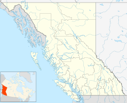
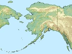
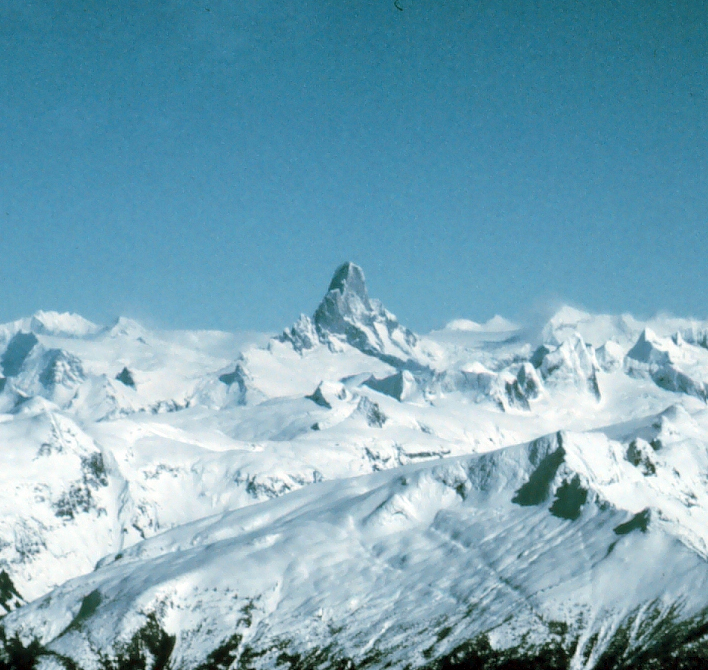
Le Devils Thumb (littéralement « Pouce des Diables » en français) est une montagne située à la limite entre l'Alaska et la Colombie-Britannique, dans les Boundary Ranges, au sein de la calotte glaciaire locale du Stikine Icecap (en), près de Petersburg.
La première ascension date de 1946, par Fred Beckey, Clifford Schmidtke, et Bob Craig.
Jon Krakauer en fait une description dans ses livres Rêves de montagnes et Voyage au bout de la solitude (Into the Wild).
Bibliographie
- Michael Wood, Colby Coombs, Alaska: A Climbing Guide, The Mountaineers, 2001
- Jonathan Krakauer, Eiger Dreams, Anchor, 1997
- American Alpine Journal, 2004, 2005
Catégories :
- Sommet de Colombie-Britannique
- Sommet des États-Unis
- Montagne de l'Alaska
Wikimedia Foundation.
2010.
Contenu soumis à la licence CC-BY-SA. Source : Article Devils Thumb de Wikipédia en français (auteurs)
Regardez d'autres dictionnaires:
Devils Thumb — For disambiguation, see Devil s Thumb (disambiguation). Not to be confused with Devils Paw, Boundary Peak 93, which is in the same mountain range. Devils Thumb … Wikipedia
Devils Paw — Not to be confused with Devils Thumb, Boundary Peak 71, which is in the same mountain range. Devils Paw Elevation 8,584 ft (2,616 m) Prominence … Wikipedia
Thumb (disambiguation) — The thumb is the first digit of the human hand.Thumb may also refer to:*ARM architecture#Thumb, an instruction state of ARM processors *Hop o My Thumb, a folk tale *Rule of thumb, an informal rule *The Thumb, a region in Michigan *The Thumb… … Wikipedia
Devil's Thumb — may refer to the following mountains or landmarks: Devils Thumb, a mountain on the Alaska/British Columbia border Devil s Thumb (Greenland), a mountain on Kullorsuaq Island in northwestern Greenland Devil s Thumb (Hot Spring), an inert hot spring … Wikipedia
Geothermal areas of Yellowstone — Map of all coordinates from Google Map of all coordinates from Bing Export all coordinates as KML … Wikipedia
Mammoth Hot Springs — Dead Trees at Mammoth Hot Springs … Wikipedia
Stikine Icecap — Infobox Glacier | glacier name = Stikine Icecap caption = The Devils Thumb rises above the Stikine Icecap type = Icecap location = Alaska, U.S., British Columbia, Canada coordinates = coord|57|04|14|N|132|13|51|W|type:glacier area = length =… … Wikipedia
Cinder Mountain — Elevation 300 m (984 ft) Location Location … Wikipedia
Stikine-Eiskappe — Der Devils Thumb über der Stikine Icecap Die Stikine Icecap (auch Stikine Icefield genannt) ist eine 21.876 km² große Eiskappe in den Boundary Ranges der Coast Mountains. Es erstreckt sich über die Grenze zwischen Alaska und der kanadischen… … Deutsch Wikipedia
Stikine Icefield — Der Devils Thumb über der Stikine Icecap Die Stikine Icecap (auch Stikine Icefield genannt) ist eine 21.876 km² große Eiskappe in den Boundary Ranges der Coast Mountains. Es erstreckt sich über die Grenze zwischen Alaska und der kanadischen… … Deutsch Wikipedia

 États-Unis
 Canada