Boundary Ranges
Contenu soumis à la licence CC-BY-SA. Source : Article Boundary Ranges de Wikipédia en français (auteurs)
Regardez d'autres dictionnaires:
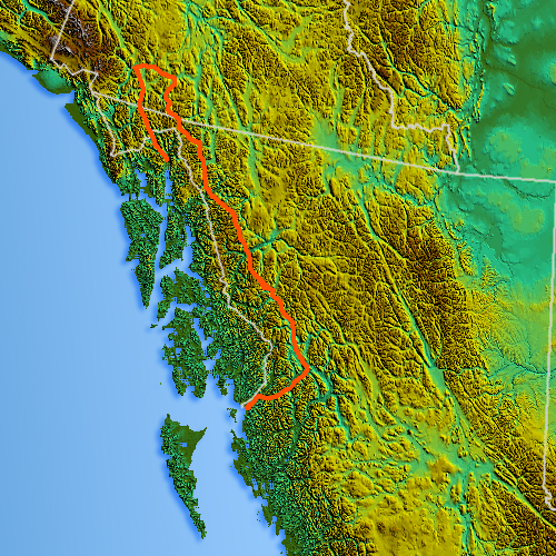
Boundary Ranges — Geobox | Range name=Boundary Ranges other name=Alaska Boundary Range image size=275 image caption=View of the Juneau Icefield. country=Canada country1=United States region=British Columbia region1=Alaska parent=Coast Mountains geology= geology1=… … Wikipedia
Boundary Ranges — Lage der Boundary Ranges … Deutsch Wikipedia
Boundary — (plural: boundaries) may refer to: Border in psychology, Personal boundaries in mathematics, Boundary (topology), the closure minus the interior of a subset of a topological space; an edge in the topology of manifolds, as in the case of a… … Wikipedia
Boundary Range — Lage der Boundary Ranges … Deutsch Wikipedia
Boundary — Cette page d’homonymie répertorie les différents sujets et articles partageant un même nom. Boundary, frontière en anglais, peut faire référence à : Boundary, une limite du terrain et une façon de marquer des points au cricket, Boundary, une … Wikipédia en Français
Boundary value analysis — is a software testing design technique used to determine test cases covering off by one errors.IntroductionTesting experience has shown that the boundaries of input ranges to a software component are likely to contain defects. For instance: a… … Wikipedia
Boundary Waters Canoe Area Wilderness — Infobox protected area | name = Boundary Waters Canoe Area Wilderness iucn category = III iucn category = Ib caption = locator x = 162 locator y = 25 location = Minnesota, USA nearest city = Ely, MN lat degrees = 47 lat minutes = 49 lat seconds … Wikipedia
Alaska Boundary Range — Lage der Boundary Ranges … Deutsch Wikipedia
Pacific Coast Ranges — Die Liste der Gebirgsketten an der nordamerikanischen Pazifikküste enthält eine Reihe von Gebirgszügen, die von Alaska bis in den Süden Mexikos reichen. Sie sind alle durch plattentektonische Kräfte entstanden, als die Farallon Platte,… … Deutsch Wikipedia
Alsek Ranges — Geobox | Range name=Alsek Ranges image caption= country=Canada country1=United States region=British Columbia | region1=Yukon| region2=Alaska parent=Saint Elias Mountains border=Fairweather Range length imperial=| length orientation= width… … Wikipedia

 Canada
 États-Unis