Branisko
- Branisko
-
49°05′N 20°55′E / 49.083, 20.917
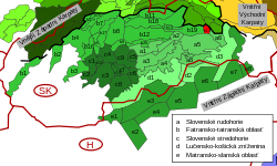
Le Branisko (polonais : Branyiszko) est une chaîne de montagne en Slovaquie orientale entre les régions de Spiš et de Šariš. La chaîne fait environ 20 km de long et 5 km de large dans une direction nord-sud et fait partie des Carpates intérieures. Son point culminant est Smrekovica à 1 200 m d'altitude.
Catégories : - Carpates occidentales
- Montagne de Slovaquie
Wikimedia Foundation.
2010.
Contenu soumis à la licence CC-BY-SA. Source : Article Branisko de Wikipédia en français (auteurs)
Regardez d'autres dictionnaires:
Branisko — may be:* Branisko (mountain range), a mountain range in eastern Slovakia between Spiš and Šariš regions. * Branisko (hill), a mountain pass and hill. * Branisko Tunnel, a motorway tunnel opened in 2003 * 11.5 km long creek in the Spiš region … Wikipedia
Branisko — ist der Name: eines Gebirges in der Slowakei, siehe Branisko (Gebirge) eines Gebirgspasses, siehe Braniskopass eines Tunnels, siehe Branisko Tunnel Diese Seite ist eine Begriffsklärung zur Unterscheidung mehrerer … Deutsch Wikipedia
Branisko (mountain range) — Branisko (or Branyiszko) is a mountain range in eastern Slovakia, between the Spiš and Šariš regions. It is a 20 km long, 5 km wide, mountain range in the north south direction, belonging to the Outer Western Carpathians. The highest hill is… … Wikipedia
Branisko-Tunnel — Der Branisko Tunnel (slowakisch Tunel Branisko) ist ein einröhriger Tunnel in der Ostslowakei zwischen Levoča und Prešov, auf der Autobahn D1. Der Tunnel ist 4975 m lang und führt durch das Branisko Gebirge zwischen den Ortschaften Beharovce im… … Deutsch Wikipedia
Branisko Tunnel — The Branisko Tunnel is a road tunnel in eastern Slovakia. It is located on the D1 motorway at Beharovce Fričovce section. It replaced the Branisko Pass road via mountain range of the same name, with the top at 751 m AMSL.… … Wikipedia
D1 motorway (Slovakia) — D1 Motorway Diaľnica D1 … Wikipedia
D1 (Slowakei) — Vorlage:Infobox hochrangige Straße/Wartung/SK D Diaľnica D1 in der Slowakei … Deutsch Wikipedia
Braniskopass — x Braniskopass Kreuz und Denkmal auf der Passhöhe … Deutsch Wikipedia
Siroke — Široké Wappen Karte … Deutsch Wikipedia
Spiš — ( Slovak; Latin: Scepusium , de. Zips, hu. Szepesség, pl. Spisz) is a region in north eastern Slovakia, with a very small area in south eastern Poland. Spiš is an informal designation of the territory (like Burgundy), but it is also the name of… … Wikipedia
 Slovaquie
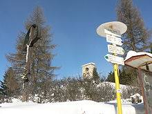 Vue du col de Branisko.

