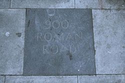
Watling Street

Watling Street

52°39′22.5″N 1°55′37.7″O / 52.65625, -1.927139

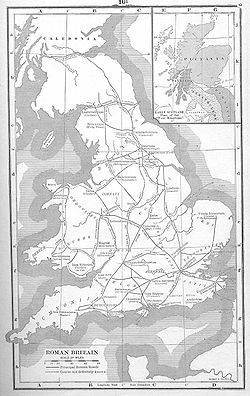
Carte des voies romaines en Bretagne romaine
Pavé gravé sur Kilburn High Road à Londres rappelant le tracé de Watling Street.

Watling Street est une voie romaine longue de 322 km qui relie le port anglais de Douvres à Viroconium, aujourd'hui Wroxeter, dans le Shropshire, au Royaume-Uni. Elle a été utilisée tout d'abord par les Celtes, principalement entre les villes modernes de St Albans et Cantorbery. Les Romains ont ensuite pavé la route, identifiée dans l'itinéraire d'Antonin à l'Iter III : Item a Londinio ad portum Dubris — de Londres au port de Douvres. Le nom vient de l'anglo-saxon Wæcelinga Stræt, signifiant « la voie du peuple de Wæcel ». le mot Street désigne à l'origine une voie pavée (latin : via strata). Le mot Wæcel peut être une variation du mot anglo-saxon désignant les Celtes vivant au Pays de Galles. Il peut venir également de Wæclingacaester, nom anglo-saxon de la ville de St Albans, et désigner ainsi la section de la route entre Londres et cette ville avant de s'étendre à toute la route.

Depuis Douvres, la voie traverse les sites romains de Cantorbery, où elle rejoint une voie venant de l'important port de Richborough (Rutupiae), Londres (Londinium), St Albans (Verulanium), où elle rejoint la voie de Akeman Street, Dunstable, Stony Stratford et Fenny Stratford, Towcester, High Cross, près de Leicester, où elle croise Fosse Way, Letocetum (Wall) et Wroxeter. Plusieurs sections poussent jusqu'au Pays de Galles et à Chester mais la Watling Street proprement dite s'arrête à Wroxeter.

En 61, quelque part le long de cette voie, le général romain Suetonius Paulinus est victorieux contre la reine Boadicée, lors d'une célèbre bataille, mettant ainsi fin à la rébellion des Bretons.

Aujourd'hui, Watling Street est toujours utilisée. La section entre Douvres et Londres s'appelle l'A2 et celle entre Londres et Shewbury l'A5. De nombreuses rues portent son nom sur son parcours.

Bibliographie

  • O. Roucoux, The Roman Watling Street: from London to High Cross, Dunstable Museum Trust, 1984
  • Thomas Codrington, Roman Roads in Britain, Londres, 1903
  • Ivan D. Margary, Roman Roads in Britain, Londres, 1967

Wikimedia Foundation. 2010.

Contenu soumis à la licence CC-BY-SA. Source : Article Watling Street de Wikipédia en français (auteurs)

Игры ⚽ Поможем сделать НИР

Regardez d'autres dictionnaires:

  • Watling Street — is the name given to an ancient trackway in England and Wales that was first used by the Celts mainly between the modern cities of Canterbury and St Albans. The Romans later paved the route, part of which is identified on the Antonine Itinerary… …   Wikipedia

  • Watling Street — bei Richborough Watling Street war eine Römerstraße in Britannien, die von Dover an der Südostküste Englands über Canterbury, London, Northampton und Birmingham nach allgemeiner Annahme nach Viroconium (heute Wroxeter …   Deutsch Wikipedia

  • Watling Street — /wotˈling strēt/ noun 1. One of the great Roman highways of Britain, running from near London through St Albans to Wroxeter 2. Often extended at either end to include the roads to Dover and Chester 3. Loosely applied to other Roman roads 4. The… …   Useful english dictionary

  • Watling Street — (spr. ŭóttling ßtrīt), alte Römerstraße in England, die von Richborough (Rutupiae) bei Sandwich über Canterbury und Rochester nach London führte, wo ein Gäßchen in der City ihren Namen trägt, und dann über St. Albans nach Wall bei Lichfield. Hier …   Meyers Großes Konversations-Lexikon

  • Watling Street — La moderna Watling Street atravesando Rochester cerca de pasos romanos y celtas. Watling Street es el nombre dado a una antigua vía situada entre Inglaterra y Gales. Los primeros que la usaron fueron los Celtas, entre las modernas ciudades de… …   Wikipedia Español

  • Watling Street —    East from St. Paul s Churchyard to Queen Street, at its junction with Queen Victoria Street (P.O. Directory). In Cordwainer and Bread Street Wards and in Farringdon Ward Within.    First mention: Street leading from Cordwainer Strete to… …   Dictionary of London

  • Watling Street — Wat|ling Street a long Roman road that started in Dover in the southeast of England, passed through London, and then went northwest to end near the modern town of Shrewsbury …   Dictionary of contemporary English

  • watling-street — n. Verlam street …   New dictionary of synonyms

  • Watling Street — a road in England, originally built by the Romans and still in use today under various different names. It runs from Dover, on the south east coast of England, through London and St Albans to Wroxeter, a small town in Shropshire. Its name comes… …   Universalium

  • Watling Street — Antiguo camino romano en Gran Bretaña. Se extiende desde Londres hasta Wroxeter y fue una de las grandes rutas arteriales de Gran Bretaña en tiempos romanos. En el s. IX dividía Mercia. Más tarde, se le dio su nombre a otros caminos importantes,… …   Enciclopedia Universal

Share the article and excerpts

Direct link
Do a right-click on the link above
and select “Copy Link”