Wagenborgen
Contenu soumis à la licence CC-BY-SA. Source : Article Wagenborgen de Wikipédia en français (auteurs)
Regardez d'autres dictionnaires:
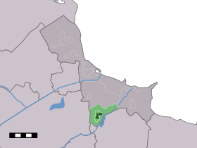
Wagenborgen — Dutch town locator maps mun town caption = The town centre (dark green) and the statistical district (light green) of Wagenborgen in the municipality of Delfzijl.Wagenborgen (coord|53|15|N|6|56|E|type:city(1755)) is a town in the Dutch province… … Wikipedia
Delfzijl — Municipality Flag … Wikipedia
The Canadian Scottish Regiment (Princess Mary's) — Infobox Military Unit unit name= The Canadian Scottish Regiment (Princess Mary s) caption=Cap badge of the Canadian Scottish Regiment dates= 3 September 1912 Present country= Canada allegiance= branch= Militia type= Infantry role= Light Infantry… … Wikipedia
List of places in the Netherlands — This is an alphabetical list of places (cities, towns, villages) in the Netherlands. Lists per province can be found at:* List of towns in Groningen * List of towns in Friesland * List of towns in Drente * List of towns in Overijssel * List of… … Wikipedia
Meedhuizen — Town … Wikipedia
Delfzijl — Gemeinde Delfzijl Flagge Wappen Provinz Groningen Bürgermeister … Deutsch Wikipedia
Dollardroute — Logo der Internationalen Dollard Route Die Internationale Dollard Route ist ein ca. 206 km langer Rundkurs für Radfahrer. Sie führt durch die deutschen Landkreise Leer und Emsland und durch die niederländische Provinz Groningen. Sie besteht seit… … Deutsch Wikipedia
Dollartroute — Logo der Internationalen Dollard Route Die Internationale Dollard Route ist ein ca. 206 km langer Rundkurs. Sie führt durch die deutschen Landkreise Leer und Emsland und durch die niederländische Provinz Groningen. Die Route und der Verein… … Deutsch Wikipedia
Bierum — Administration Pays Pays Bas Province Groningue Commune … Wikipédia en Français
Biessum — 53°20′3″N 6°53′51″E / 53.33417, 6.8975 … Wikipédia en Français
 Pays-Bas