Thórisjokull
- Thórisjokull
-
Þórisjökull
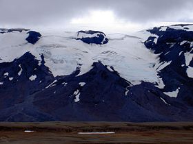
Le Þórisjökull est un glacier d'Islande, long de 1350 m, situé entre le glacier Langjökull dont il fut une partie autrefois et le volcan Ok.
La route de Kaldidalur qui est une des routes traversant les Hautes Terres d'Islande passe par la vallée entre Ok et Þórisjökull.
Voir aussi
Articles connexes
 Portail de l’Islande
 Portail de la montagne
Catégorie : Glacier d'Islande
Wikimedia Foundation.
2010.
Contenu soumis à la licence CC-BY-SA. Source : Article Thórisjokull de Wikipédia en français (auteurs)
Regardez d'autres dictionnaires:
Thorisjökull — Þórisjökull Þórisjökull von der Piste Uxarhryggarvegur Der Þórisjökull (Thórisjökull) ist ein Gletscher im Westen Islands. Er bef … Deutsch Wikipedia
Thórisjökull — Þórisjökull Þórisjökull von der Piste Uxarhryggarvegur Der Þórisjökull (Thórisjökull) ist ein Gletscher im Westen Islands. Er bef … Deutsch Wikipedia
Thorisjokull — Þórisjökull Þórisjökull Le glacier Latitude Longitude … Wikipédia en Français
Thorisjökull — Þórisjökull Þórisjökull Le glacier Latitude Longitude … Wikipédia en Français
Thórisjökull — Þórisjökull Þórisjökull Le glacier Latitude Longitude … Wikipédia en Français
Þórisjökull — Höhe 1.350 m … Deutsch Wikipedia
Þorisjokull — Þórisjökull Þórisjökull Le glacier Latitude Longitude … Wikipédia en Français
Тоурисйёкудль — исл. Þórisjökull … Википедия
 Islande


