Ashibetsu

Ashibetsu
Ashibetsu-shi (芦別市)
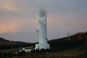
Kannon in Ashibetsu.JPG
Avalokiteśvara de Ashibetsu
Administration
Pays Japon
Région Hokkaidō
Préfecture Hokkaidō
Code postal 〒075-8711
Maire Masashi Hayashi
Site web Site officiel
Démographie
Population 17 211 hab. (mars 2010)
Densité 20 hab./km2
Géographie
Coordonnées 43° 31′ 06″ Nord
       142° 11′ 22″ Est
/ 43.518333, 142.189444
Superficie 865,02 km2

Géolocalisation sur la carte : Japon

(Voir situation sur carte : Japon)
Ashibetsu-shi
Localisation dans la préfecture

Ashibetsu (japonais: 芦別市; -shi, aïnou: Aspet) est une ville située dans la sous-préfecture de Sorachi sur l'île de Hokkaidō au Japon.

En 2007 la population était estimée à 17 211 habitants et sa densité était de 19,9 personnes par km². La superficie totale est de 865,02 km². La ville fut une cité prospère grâce à ses mines de charbon où sa population dépassait les 70 000 habitants, mais depuis la fermeture de la mine la densité de population s'est effondrée.

Histoire

  • 1893 Satō Denjirō (originaire de la Préfecture de Yamagata fonde Ashibetsu
  • 1897 Le village de Nae (actuellement Sunagawa) et une partie du village de Takikawa fondèrent le village d'Utashinai
  • 1900 Le village d'Ashibetsu fut fondé par le villaged'Utashinai.
  • 1906 Ashibetsu devient une municipalité de Seconde Classe
  • 1923 Municipalité de Première Classe
  • 1924 Ouverture de la mine d'Ashibetsu
  • 1935 Ouverture de la mine de Kamiashibetsu
  • 1938 Ouverture de la mine de Ashibetsu-Takane
  • 1941 Le village d'Ashibetsu devient la ville d'Ashibetsu
  • 1943 Ouerture de la mine de Mitsui-Ashibetsu
  • 1953 Ashibetsu devient la ville d'Ashibetsu
  • 1997 Ouverture du "Canadian World park"
  • 1999 faillite commerciale du "Canadian World"

Liens externes


Wikimedia Foundation. 2010.

Contenu soumis à la licence CC-BY-SA. Source : Article Ashibetsu de Wikipédia en français (auteurs)

Игры ⚽ Поможем сделать НИР

Regardez d'autres dictionnaires:

  • Ashibetsu — shi 芦別市 …   Deutsch Wikipedia

  • Ashibetsu — Original name in latin Ashibetsu Name in other language Ashibetsu, Shimo ashibetsu State code JP Continent/City Asia/Tokyo longitude 43.50972 latitude 142.18556 altitude 111 Population 19108 Date 2012 01 19 …   Cities with a population over 1000 database

  • Ashibetsu, Hokkaidō — nihongo|Ashibetsu|芦別市|Ashibetsu shi|Ainu: Aspet is a city located in Sorachi Subprefecture, Hokkaidō, Japan.As of 2007, the city has an estimated population of 18,310 and a density of 22.84 persons per km². The total area is 865.07 km². The city… …   Wikipedia

  • Ashibetsu Dam — this article requires translation from Japanese wikipedia. You can help English wikipedia by translating it. Infobox Dam dam name= Ashibetsu Dam caption= official name= crosses=Sorachi River reservoir= locale= Hokkaidō, flag|Japan. maint= length …   Wikipedia

  • Ashibetsu Station — PAGENAME is a railway station of JR Hokkaido Nemuro Main Line located in Ashibetsu, Hokkaidō, Japan which opened at Nov. 10, 1913.External links …   Wikipedia

  • Ashibetsu-shi — Admin ASC 2 Code Orig. name Ashibetsu shi Country and Admin Code JP.12.2130609 JP …   World countries Adminstrative division ASC I-II

  • Mount Ashibetsu — 芦別岳 Mount Ashibetsu from Yamabe Station in Furano (April 2009) …   Wikipedia

  • Kami-Ashibetsu Station — PAGENAME is a railway station of JR Hokkaido Nemuro Main Line located in Ashibetsu, Hokkaidō, Japan which opened at Jan. 16, 1920.External links …   Wikipedia

  • Hokkaidō Prefectural Board of Education — Hokkaido Prefectural Board of Education (北海道教育委員会) is a governmental agency that oversees public schools in Hokkaidō in Japan.The board directly oversees high schools in Hokkaidō.High schools [http://www.ipec.hokkaido c.ed.jp/links/gakkou.html]… …   Wikipedia

  • Mikasa (Hokkaido) — 三笠市 Mikasa shi …   Deutsch Wikipedia

Share the article and excerpts

Direct link
Do a right-click on the link above
and select “Copy Link”