Perthshire and Kinross
- Perthshire and Kinross
-
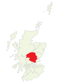
Perth and Kinross
Le Perth and Kinross est une région du centre de l'Écosse qui correspond aux anciens comtés de Perth et de Kinross.
Il est situé entre Highland et Lowlands, en partie sur le massif des Monts Grampians entrecoupé de vallées dans laquelle s'est développée une agriculture basée sur l'élevage (bovins, moutons, etc.). La région est traversée par le Tay qui est la plus grosse rivière de Grande-Bretagne à défaut d'en être la plus longue, ce qui s'explique par le niveau important des précipitations dans l'ouest de l'Écosse où le Tay prend sa source.
 Portail de l’Écosse
Catégorie : District écossais
Wikimedia Foundation.
2010.
Contenu soumis à la licence CC-BY-SA. Source : Article Perthshire and Kinross de Wikipédia en français (auteurs)
Regardez d'autres dictionnaires:
Perth and Kinross — This article is about the Scottish local government area. For the former UK Parliamentary constituency abolished in 1997, see Perth and Kinross (UK Parliament constituency). Perth and Kinross Pairth an Kinross Peairt agus Ceann Rois Location … Wikipedia
Perth and Kinross — noun an administrative district in northern central Scotland; formed from the former counties of Perthshire and Kinross shire which became part of Tayside region in 1975; became a unitary district in 1996. 5321 km2. Administrative Centre: Perth …
Perth and Kinross — Peairt agus Ceann Rois Verwaltungssitz Perth Fläche … Deutsch Wikipedia
Perth and Kinross — ▪ council area, Scotland, United Kingdom council area, central Scotland. It encompasses the historic county of Kinross shire (Kinross, which covers a small area in the southeast), a very small portion of the historic county of Angus (south… … Universalium
Clackmannanshire and Kinross-shire (UK Parliament constituency) — Clackmannanshire and Kinross shire Former County constituency for the House of Commons Subdivisions of Scotland Clackmannanshire, Kinross shire 1708 … Wikipedia
Methven, Perth and Kinross — Coordinates: 56°24′54″N 3°34′48″W / 56.415°N 3.580°W / 56.415; 3.580 … Wikipedia
Blackford (Perth and Kinross) — Blackford Koordinaten 56° 16′ N … Deutsch Wikipedia
Perth and Kinross Council — is the local government council for the Perth and Kinross council area of Scotland. It employs nearly 5000 employees.The council was created in 1996, under the Local Government etc. (Scotland) Act 1994, when the Tayside region was divided between … Wikipedia
Scone (Perth and Kinross) — Scone Koordinaten 56° 26′ N … Deutsch Wikipedia
Aberfeldy (Perth and Kinross) — Aberfeldy Koordinaten 56° 37′� … Deutsch Wikipedia