Mavis Grind
- Mavis Grind
-
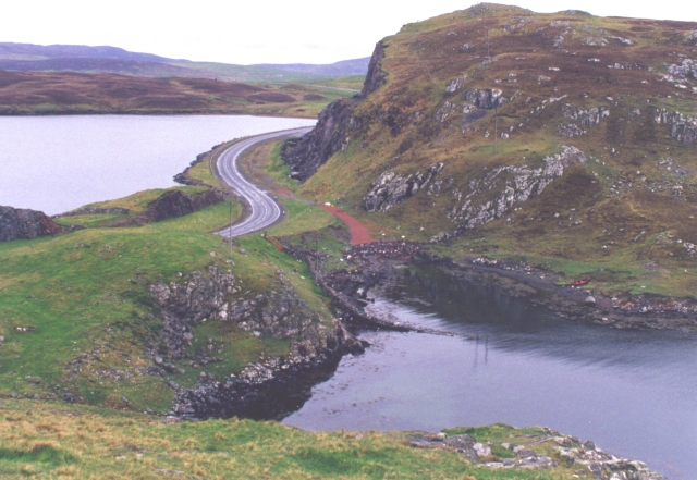
La A970 sur Mavis Grind.
A droite,
une branche de l'
océan atlantique et à gauche,
Sullom Voe,
une crique de la mer du Nord.
60°23′53″N 1°23′6″O / 60.39806, -1.385 Mavis Grind est un isthme britannique étroit reliant la presqu'île de Northmavine au reste de Mainland, une île de l'océan Atlantique relevant de l'archipel écossais des Shetland. Mavis Grind signifie « la porte de l'isthme étroit » dans le dialecte local, cet isthme ne mesurant qu'une trentaine de mètres à l'endroit le plus étroit. La route A970 y passe en direction de Hillswick, au nord-ouest des Shetland, et se trouve à quelques kilomètres du village de Brae.
En raison de l'étroitesse de l'isthme, il est dit qu'il s'agit du seul endroit au Royaume-Uni où on peut lancer une pierre par-dessus terre de la Mer du Nord à l'Océan Atlantique. Il s'agit d'un point de passage régulier pour les loutres, qui dans les Shetland vivent en mer : ainsi, c'est également l'un des rares endroits au Royaume-Uni, sinon le seul, où un panneau routier prévient les conducteurs qu'ils peuvent croiser des loutres.
Voir aussi
Articles connexes
Wikimedia Foundation.
2010.
Contenu soumis à la licence CC-BY-SA. Source : Article Mavis Grind de Wikipédia en français (auteurs)
Regardez d'autres dictionnaires:
Mavis Grind — (Old Norse: Mæfeið) is a narrow isthmus joining the Northmavine peninsula to the rest of the island of Shetland Mainland in the Shetland Islands, UK. It is just 33 metres (108 ft) wide at its narrowest point. The name means gate of the… … Wikipedia
Mavis (disambiguation) — For the given name and list of namesakes see Mavis. Mavis may also refer to: In geography: Mavis (crater), a small lunar crater adjacent to Mons La Hire Mavis Banks, Jamaican coffee growing community Mavis Enderby, village in Lincolnshire,… … Wikipedia
Islesburgh Cairn — ist eine neolithische Megalithanlage, westlich von Brae am Mavis Grind, jener 33 m breiten Landbrücke zwischen der Northmavine Halbinsel im Nordwesten und dem Rest des Mainlands der Shetlands. Inhaltsverzeichnis 1 Der Cairn 2 Die Einfriedung 3… … Deutsch Wikipedia
Northmavine — The chambered cairn on Ronas Hill Northmavine (Old Norse: Norðan Mæfeið, meaning the land North of the Mæfeið isthmus (Mavis Grind) ) is a peninsula of Shetland in Scotland. It is in the north west of the island, and contains the villages of… … Wikipedia
List of Shetland islands — This is a list of Shetland islands in Scotland. The Shetland archipelago is located 100 kilometres (62 miles) north of mainland Scotland and the capital Lerwick is almost equidistant from Bergen in Norway and Aberdeen in Scotland. The Shetland… … Wikipedia
Northmavine — 60°30′N 1°24′W / 60.5, 1.4 … Wikipédia en Français
Shetland — For other uses, see Shetland (disambiguation). Shetland Sealtainn … Wikipedia
Portage — TOCleftPortage refers to the practice of carrying a canoe or other boat over land to avoid an obstacle on the water route (such as rapids or a waterfall in a river), or between two bodies of water (such as over an isthmus). A place where this… … Wikipedia
Isthmus — An isthmus is a narrow strip of land connecting two larger land areas. Many canals are built on isthmi where it is particularly advantageous to create a shortcut for marine transportation. Of note is the Panama Canal, which connects the Atlantic… … Wikipedia
Mainland, Shetland — Location OS grid reference … Wikipedia

 Portail du monde maritime
 Portail de l’Écosse