- Mainland (Shetland)
-
 Pour les articles homonymes, voir Mainland.
Mainland Géographie Pays  Royaume-Uni
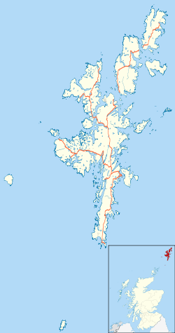
Archipel Shetland Localisation Océan Atlantique Coordonnées Superficie 968,79 km2 Point culminant Ronas Hill (450 m) Géologie Île continentale Administration Royaume-UniNation constitutive Écosse Council Area Shetland Démographie Population 17 550 hab. (2001) Densité 18,12 hab./km2 Plus grande ville Lerwick Autres informations Découverte Préhistoire Fuseau horaire UTC+0 Géolocalisation sur la carte : Shetland
 Mainland
Géolocalisation sur la carte : Royaume-Uni
 Mainland
Îles du Royaume-Uni Mainland est l'île principale de l'archipel des Shetland. Elle a une superficie de 970 km² ce qui en fait la troisième plus grande île écossaise et la cinquième des Îles Britanniques (après la Grande-Bretagne, l'Irlande, Lewis et Harris et Skye). Elle mesure 81 km de long du nord au sud et 42 km dans sa plus grande largeur. Sa population est de 17.550 habitants principalement regroupés à Lerwick seule agglomération de l'île et de l'archipel.
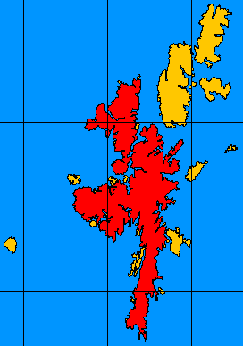
Mainland peut se diviser grossièrement en quatre parties :
- South Mainland, la longue péninsule méridionale, au sud de Lerwick, un mélange de tourbières et des zones d'élevage. Elle comprend de nombreux sites archéologiques.
- Bigton
- Sandwick
- Scalloway
- Sumburgh
- Central Mainland, la partie centrale de l'île qui comprend le plus de terres fermières et des plantations forestières.
- West Mainland
- Aith
- Walls
- North Mainland - avec en particulier la grande péninsule Northmavine, relié à Mainland par un isthme étroit à Mavis Grind - est sauvage avec de nombreuses tourbières et une côte composée de falaises. Le North Mainland comprend Sullom Voe, son terminal pétrolier est une des principaux fournisseur d'emploi des îliens.
- Brae
- North Roe
- Vidlin
 Carte de Mainland
Source
- (en) Cet article est partiellement ou en totalité issu de l’article de Wikipédia en anglais intitulé « Mainland, Shetland » (voir la liste des auteurs)
Catégories :- Île des Shetland
- Île de la mer du Nord
- Île de la mer de Norvège
- South Mainland, la longue péninsule méridionale, au sud de Lerwick, un mélange de tourbières et des zones d'élevage. Elle comprend de nombreux sites archéologiques.


Wikimedia Foundation. 2010.