London Borough de Croydon
- London Borough de Croydon
-
Croydon (district londonien)
District londonien de Croydon
|
| Géographie |
| Statut |
London borough |
Superficie
— Total |
Rang: 256e
86,52 km² |
| Démographie |
Population
— Total (2005 est.)
— Densité |
Rang: 9e (sur les 354)
342 700
3 961 / km² |
| Groupes ethniques |
70.2% Caucasiens
13.3% Afro-Caribbéen
11.3% Asiatiques du Sud
2.1% Chinois |
| Politique |
| Type de gouvernement |
Leader & Cabinet |
| Maire |
Janet Marshall |
| Parti au pouvoir |
Conservateur |
| Députés |
Richard Ottaway (Con)
Andrew Pelling (Con)
Malcolm Wicks (Lab) |
Assemblée du Grand Londres
— Membre |
Croydon et Sutton
Stephen O'Connell (Con) |
| Site officiel |
http://www.croydon.gov.uk/ |
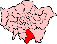
Le district londonien de Croydon (« London Borough of Croydon ») est un district du Grand Londres. Cette circonscription, fondée en 1965 par fusion des districts de Croydon et de Coulsdon and Purley, compte plus de 336 000 habitants.
Le district se compose de :
- Addington
- Addiscombe
- Broad Green
- Coombe
- Coulsdon
- Croydon
- Forestdale
- Hamsey Green
- Kenley
- New Addington
- Norbury
- Purley
- Sanderstead
- Selhurst
- Selsdon
- Shirley
- South Croydon
- South Norwood
- Thornton Heath
- Upper Norwood
- Waddon
- West Croydon
- Woodcote
- Woodside
| Districts de Croydon |
|
|
Addington | Addiscombe | Broad Green | Coombe | Coulsdon | Croydon | Forestdale | Hamsey Green | Kenley | New Addington | Norbury | Purley | Sanderstead | Selhurst | Selsdon | Shirley | South Croydon | South Norwood | Thornton Heath | Upper Norwood | Waddon | West Croydon | Woodcote | Woodside |
|
Catégories : District londonien | Croydon (district londonien)
Wikimedia Foundation.
2010.
Contenu soumis à la licence CC-BY-SA. Source : Article London Borough de Croydon de Wikipédia en français (auteurs)
Regardez d'autres dictionnaires:
London Borough of Croydon — Lage in Greater London Status London Borough Region … Deutsch Wikipedia
London Borough of Croydon — For other places called Croydon, see Croydon (disambiguation). For the historic town located within the London Borough which gives the name, see Croydon. London Borough of Croydon London borough … Wikipedia
List of schools in the London Borough of Croydon — The London Borough of Croydon is one of the boroughs in London with the most schools. They include primary schools (95), secondary schools (21) and four further education establishments.cite web|year = 2008|url =… … Wikipedia
List of stations in the London Borough of Croydon — This is a list of stations in London Borough of Croydon. It includes all stations on the Network Rail Mainline Services that are open and Tramlink stops. Also see list of London railway stations for a larger look of stations around the capital.… … Wikipedia
London Borough of Merton — London borough Coat of arms … Wikipedia
London Borough of Southwark — London borough Coat of arms … Wikipedia
London Borough of Harrow — London borough Coat of arms … Wikipedia
London Borough of Sutton — Infobox London Borough | name = London Borough of Sutton short name = Sutton imagename = status = London borough | area rank = 310th area km2 = 43.85 ons code = 00BF | adminhq = Sutton ethnicity = 89.2% White 4.7% South Asian 2.6% African… … Wikipedia
County Borough of Croydon — Croydon Motto: Sanitate Crescimus (May we grow in health) Geography Status Local board of health (until 1883) Municipal borough (1883 – 1889) County borough (after 1889) … Wikipedia
London Borough of Tower Hamlets — Lage in Greater London Status London Borough Region … Deutsch Wikipedia