Amargosa Range
Contenu soumis à la licence CC-BY-SA. Source : Article Amargosa Range de Wikipédia en français (auteurs)
Regardez d'autres dictionnaires:
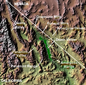
Amargosa Range — The Amargosa Range is a mountain range in Inyo County, California and Nye County, Nevada. The 110 mile (180 km) range runs along most of the eastern side of California s Death Valley, separating it from Nevada s Amargosa Desert. The U shaped… … Wikipedia
Amargosa Range — ▪ mountains, United States group of mountains in eastern California and southern Nevada, U.S., separating Death Valley from the Amargosa Desert. Part of the Basin Ranges of eastern California, the Amargosa Range extends 110 miles (180 km)… … Universalium
Amargosa Range — Sp Amargòsos kalnãgūbris Ap Amargosa Range L JAV (Kalifornija ir Nevada) … Pasaulio vietovardžiai. Internetinė duomenų bazė
Amargosa River — The Amargosa River is an intermittent stream, approximately 200 mi (320 km) long, in southern Nevada and eastern California in the United States. It drains a high desert region northwest of Las Vegas into Death Valley, where it disappears into… … Wikipedia
Amargosa Valley, Nevada — For the geographic valley in Nevada, see Amargosa Valley.Amargosa Valley (formerly Lathrop Wells) is a town located in Nye County, Nevada. As of the 2000 census, the town had a total population of 1,176. An interim census report issued in August … Wikipedia
Amargosa Valley — For the town in Nevada, see Amargosa Valley, NevadaThe Amargosa Valley is a valley which straddles the border of the states of California and Nevada. It is named for the river which flows through it, the Amargosa River. The name likely derives… … Wikipedia
Amargosa Toad — Conservation status Endangered (IUCN 3.1 … Wikipedia
Amargosa Desert — The Amargosa Desert is located in western Nevada, USA, along the border with California. It is largely coincident with the geographic Amargosa Valley. The desert lies at an elevation of about 2,600 2,750 feet, and includes the community of… … Wikipedia
Greenwater Range — The Greenwater Range is a mountain range located in the eastern Mojave Desert of California in the United States. The mountains lie a short distance to the east of the Amargosa Range and the Black Mountains, and south of the Funeral Mountains.… … Wikipedia
Resting Spring Range — The Resting Spring Range is found in the eastern Mojave Desert of California near the Nevada state line in the United States. The range lies in a generally north south direction to the west of the Nopah Range and southeast of the Amargosa Range… … Wikipedia
 États-Unis