Kanab River
- Kanab River
-
Kanab (rivière)
La rivière Kanab est une rivière de l'Utah et de l'Arizona aux États-Unis, affluent du fleuve Colorado.
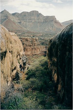
Parcours
La rivière débute dans le comté de Kane, Utah, juste au sud du Grand Bassin et coule sur 145 kilomètres en direction du sud vers le fleuve Colorado. Elle traverse Kanab dans l'Utah, puis rentre dans l'Arizona près de Fredonia, Arizona, et passe à travers une réserve indienne d'amérindiens païutes (Kaibab Indian Reservation) pour se jeter dans le Colorado au niveau du Grand Canyon
Histoire
La vallée de la rivière Kanab a d'abord été habitée par des amérindiens anasazis dont on peut voir des ruines le long du cours d'eau.
Liens externes
Notes et références
 Portail de l’eau
 Portail des États-Unis
Catégories : Système hydrologique du Colorado | Cours d'eau de l'Utah | Cours d'eau de l'Arizona
Wikimedia Foundation.
2010.
Contenu soumis à la licence CC-BY-SA. Source : Article Kanab River de Wikipédia en français (auteurs)
Regardez d'autres dictionnaires:
Kanab ambersnail — A Kanab ambersnail at Vasey s Paradise in Grand Canyon National Park. Conservation status … Wikipedia
Kanab Creek — im Kanab CanyonVorlage:Infobox Fluss/KARTE fehlt DatenVorlage:Infobox Fl … Deutsch Wikipedia
Kanab Creek — Kanab (rivière) Kanab Caractéristiques Longueur 145 km Bassin ? … Wikipédia en Français
Kanab Creek — is one of the many tributaries of the Grand Canyon. It begins in Kane County, Utah just south of the watershed to the Great Basin and flows south toward the Colorado River. It passes Kanab, Utah, crosses the border to Arizona near Fredonia,… … Wikipedia
Kanab Creek Wilderness — Infobox protected area | name = Kanab Creek Wilderness iucn category = Ib caption = locator x = 57 locator y = 99 location = Arizona, USA nearest city = San Manuel, AZ lat degrees = lat minutes = lat seconds = lat direction = N long degrees =… … Wikipedia
Kanab (rivière) — 37° 29′ 31″ N 112° 22′ 48″ W / 37.4919, 112.38 … Wikipédia en Français
Colorado River — This article is about the river that flows through the Grand Canyon. For other rivers named Colorado, see Colorado River (disambiguation). Coordinates: 31°39′N 114°38′W / 31.65°N 1 … Wikipedia
Colorado River Compact — The Colorado River Compact is a 1922 agreement among seven U.S. states in the basin of the Colorado River in the American Southwest governing the allocation of the water rights to the river s water among the parties of the interstate compact. The … Wikipedia
Colorado River Delta — as seen from space (2004); Isla Montague is the large island in the center. The Colorado River Delta is the region where the Colorado River flows into the Gulf of California (also known as the Sea of Cortez). The delta is part of a larger… … Wikipedia
Colorado River Storage Project — Glen Canyon Dam and Lake Powell near Page, Arizona. The dam and lake are major components in the Colorado River Storage Project s attempt to regulate the flow of the Colorado River. The Colorado River Storage Project is a United States Bureau of… … Wikipedia
 États-Unis
 Utah,
Utah,  Arizona