Kanab Creek
- Kanab Creek
-
Kanab (rivière)
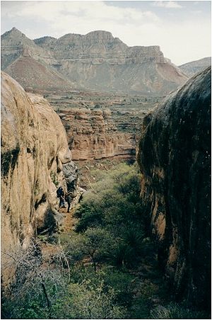
La rivière Kanab est une rivière de l'Utah et de l'Arizona aux États-Unis, affluent du fleuve Colorado.
Parcours
La rivière débute dans le comté de Kane, Utah, juste au sud du Grand Bassin et coule sur 145 kilomètres en direction du sud vers le fleuve Colorado. Elle traverse Kanab dans l'Utah, puis rentre dans l'Arizona près de Fredonia, Arizona, et passe à travers une réserve indienne d'amérindiens païutes (Kaibab Indian Reservation) pour se jeter dans le Colorado au niveau du Grand Canyon
Histoire
La vallée de la rivière Kanab a d'abord été habitée par des amérindiens anasazis dont on peut voir des ruines le long du cours d'eau.
Liens externes
Notes et références
 Portail de l’eau
 Portail des États-Unis
Catégories : Système hydrologique du Colorado | Cours d'eau de l'Utah | Cours d'eau de l'Arizona
Wikimedia Foundation.
2010.
Contenu soumis à la licence CC-BY-SA. Source : Article Kanab Creek de Wikipédia en français (auteurs)
Regardez d'autres dictionnaires:
Kanab Creek — im Kanab CanyonVorlage:Infobox Fluss/KARTE fehlt DatenVorlage:Infobox Fl … Deutsch Wikipedia
Kanab Creek — is one of the many tributaries of the Grand Canyon. It begins in Kane County, Utah just south of the watershed to the Great Basin and flows south toward the Colorado River. It passes Kanab, Utah, crosses the border to Arizona near Fredonia,… … Wikipedia
Kanab Creek Wilderness — Infobox protected area | name = Kanab Creek Wilderness iucn category = Ib caption = locator x = 57 locator y = 99 location = Arizona, USA nearest city = San Manuel, AZ lat degrees = lat minutes = lat seconds = lat direction = N long degrees =… … Wikipedia
Kanab Creek Trail — Infobox Hiking trail Name=Kanab Creek Trail Photo= Kanab canyon.jpg Caption= Kanab Canyon Length= Location=coord|36.3923|N|112.6296|W|display=inline,title Grand Canyon National Park, Arizona, United States Start/End Points= Use=Hiking ElevChange … Wikipedia
Kanab — ▪ Utah, United States city, seat (1864) of Kane county, southwestern Utah, U.S., on Kanab Creek, at the foot of Vermilion Cliffs, just north of the Arizona line. Settlement was first made in 1864 around Fort Kanab (from a Paiute Indian word… … Universalium
Clear Creek Trail — The Clear Creek Stream in the Grand Canyon Length 8.4 miles (13.5 km) Location Grand Canyon National Park, Arizona, United State … Wikipedia
Deer Creek Trail — Length 3.1 mi (5.0 km) Location Grand Canyon National Park, Arizona, United States Trailheads Colorado River Thunder River Trail, Grand Canyon North Rim Use Hiking Backpacking … Wikipedia
Duck Creek Village, Utah — Duck Creek Village Unincorporated community … Wikipedia
U.S. Route 89 in Utah — U.S. Route 89 Map of US 89 (delineated in red) Route information … Wikipedia
List of Arizona Wilderness Areas — This is a List of Arizona Wilderness Areas. A second list contains the geographic landform that is most closely associated with it, or is in its proximity.Note: LCRV = Lower Colorado River Valley List of Arizona wilderness areas*Apache Creek… … Wikipedia
 États-Unis
 Utah,
Utah,  Arizona