Altforst
Contenu soumis à la licence CC-BY-SA. Source : Article Altforst de Wikipédia en français (auteurs)
Regardez d'autres dictionnaires:
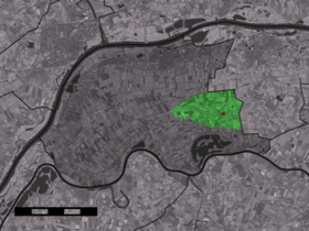
Altforst — Dutch town locator maps mun town caption = The town centre (red) and the statistical district (light green) of Altforst in the municipality of West Maas en Waal.Altforst (coord|51|51|N|5|34|E|type:city(113)) is a village in the Dutch province of… … Wikipedia
Forst/Lausitz — Wappen Deutschlandkarte … Deutsch Wikipedia
Forst (Lausitz) — Wappen Deutschlandkarte … Deutsch Wikipedia
West Maas en Waal — Infobox Settlement official name = West Maas en Waal mapsize = 280px subdivision type = Country subdivision name = Netherlands subdivision type1 = Province subdivision name1 = Gelderland area footnotes = (2006) area total km2 = 85.15 area land… … Wikipedia
List of places in the Netherlands — This is an alphabetical list of places (cities, towns, villages) in the Netherlands. Lists per province can be found at:* List of towns in Groningen * List of towns in Friesland * List of towns in Drente * List of towns in Overijssel * List of… … Wikipedia
Karmijn de Sonnaville — is a variety of apple bred by Piet de Sonnaville, working in Wageningen (the Netherlands) in 1949. It is a cross of Cox’s Orange Pippin and Jonathan, and was first grown commercially beginning in 1971.It is high in both sugars (including some… … Wikipedia
Beneden-Leeuwen — Gemeinde West Maas en Waal Flagge Wappen Provinz … Deutsch Wikipedia
West Maas en Waal — Gemeinde West Maas en Waal Flagge Wappen Provinz … Deutsch Wikipedia
West Maas und Waal — Gemeinde West Maas en Waal Flagge Wappen Provinz … Deutsch Wikipedia
Alphen (Gueldre) — 51°49′17″N 5°28′17″E / 51.82139, 5.47139 … Wikipédia en Français
 Pays-Bas

