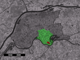
Maasbommel
Contenu soumis à la licence CC-BY-SA. Source : Article Maasbommel de Wikipédia en français (auteurs)
Regardez d'autres dictionnaires:
Maasbommel — Dutch town locator maps mun town caption = The town centre (red) and the statistical district (light green) of Maasbommel in the municipality of West Maas en Waal.Maasbommel (coord|51|49|N|5|32|E|type:city(615)) is a town in the Dutch province of … Wikipedia
de Gouden Kust 1 — (Maasbommel,Нидерланды) Категория отеля: Адрес: 6627 KS Maasbommel, Нидерланды Описание: de Gouden Kust … Каталог отелей
de Gouden Kust 2 — (Maasbommel,Нидерланды) Категория отеля: Адрес: 6627 KS Maasbommel, Нидерланды Описание: de Gouden Kust … Каталог отелей
Gouden Kust — (Maasbommel,Нидерланды) Категория отеля: 4 звездочный отель Адрес: 6627KS Maasbommel, Ни … Каталог отелей
Samuel Story — Infobox Military Person name= Samuel Story lived= October 2 1752 ndash; January 8 1811 placeofbirth= Maasbommel, Dutch Republic placeofdeath= Cleves caption= nickname= allegiance=Batavian Republic serviceyears= 1770 – 1804 rank= vice admiral… … Wikipedia
Beneden-Leeuwen — Gemeinde West Maas en Waal Flagge Wappen Provinz … Deutsch Wikipedia
West Maas en Waal — Gemeinde West Maas en Waal Flagge Wappen Provinz … Deutsch Wikipedia
West Maas und Waal — Gemeinde West Maas en Waal Flagge Wappen Provinz … Deutsch Wikipedia
Guelders — This article deals with the historical county and duchy of Guelders, for other meanings see Gelderland. Duchy of Guelders Hertogdom Gelre (nl) Herzogtum Geldern (de) State of the Holy Roman Empire … Wikipedia
West Maas en Waal — Infobox Settlement official name = West Maas en Waal mapsize = 280px subdivision type = Country subdivision name = Netherlands subdivision type1 = Province subdivision name1 = Gelderland area footnotes = (2006) area total km2 = 85.15 area land… … Wikipedia
 Pays-Bas

