- Inner London
-
 Inner London au sein du Grand Londres.
Inner London est nom donné à un ensemble de districts centraux du Grand Londres, entouré par l'Outer London. La première définition officielle de cette zone date de 1965[1] mais pour des raisons statistiques, cette définition a changé au fil des temps[2]. Cependant, les termes Inner London et Central London ne sont pas équivalents et ne peuvent pas être interchangés.
Cette zone est l'une des plus riches de l'Union européenne avec un PIB par personne de 61 516 € en 2004[3], juste après Paris (67 870€ en 2006) [4].
Sommaire
Définition de I'Inner London Education Authority (1965)
Inner London (Def. de l'ILEA) Inner London (Def. de l'ONS) 
Lorsque fut créée l’Inner London Education Authority en 1965, l'Inner London a été défini comme l'ensemble des districts londoniens qui formaient l'ancien comté de Londres :
- Camden
- Greenwich
- Hackney
- Hammersmith et Fulham
- Islington
- Kensington et Chelsea
- Lambeth
- Lewisham
- Southwark
- Tower Hamlets
- Wandsworth
- Cité de Westminster
La Cité de Londres faisait partie du comté de Londres, mais n'était pas considérée comme un district, mais peut être incluse à l'Inner London. Le cas de North Woolwich est spécial car ce quartier ne faisait pas partie du comté de Londres mais a été transféré à Newham en 1965.
Définition de l'Office for National Statistics
L'Office for National Statistics et les services de recensement utilisent le terme Inner London en y incluant les districts de Haringey et Newham mais en excluant Greenwich qui est classé dans l' Outer London. Cette définition est également utilisée par Eurostat pour classer l' Inner London en NUTS de niveau 2. Cette zone s’étend sur 319 km2 et la population est estimée à 2 985 700 (2005).
Population
Les chiffres d'avant 1971 ont été modifiés par l'Office for National Statistics pour correspondre aux frontières de 2001. À partir de 1981, les chiffres sont des estimations réalisées au milieu de l'année.
Année Date Population 1891 5-6 avril 4 488 242 1901 31 mars-1er avril 4 859 558 1911 2-3 avril 4 998 237 1921 19-20 juin 4 972 870 1931 26-27 avril 4 893 261 1939 Estimation 4 364 457 1951 8-9 avril 3 679 390 1961 23-24 avril 3 496 879 1971 25-26 avril 3 031 935 1981 Estimation 2 550 100 1991 Estimation 2 599 300 2001 Estimation 2 859 400 2003 Estimation 2 904 600 2004 Estimation 2 931 100 2005 Estimation 2 985 700 Autres définitions
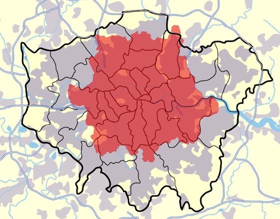
 Districts postaux de Londres (en rouge) au sein du Grand Londres
La zone couverte par les districts postaux de Londres est souvent appelée Inner London [5]. Cette zone est cependant plus étendue et couvre 624 km2. 44 de ses 119 districts se trouvent dans l'Outer London et s'étendent jusqu'à la frontière du Grand Londres Scratch Wood et même au-delà, jusqu'à Sewardstone.
De 1990 à 2000, Londres a utilisé deux indices téléphoniques différents avec un code spécial pour l'Inner London, cependant la zone correspondant à ce code était largement différente des définitions données précédemment et aujourd'hui, la ville est couverte par l'unique code 020.
Références
- Saint, A., Politics and the people of London: the London County Council (1889-1965), (1989)
- Newham London Borough Council - Positively Inner London
- Central London fact file
- www.citymayors.com - European cities outperform their English counterparts
- HMSO, The Inner London Letter Post, (1980)
Catégorie :- Géographie de Londres
Wikimedia Foundation. 2010.