I-Tsing
- I-Tsing
-
Yi Jing (moine)

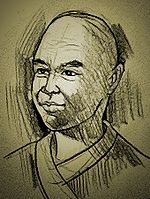
Vue d' artiste de Yi Jing 义净( 635- 713)
|

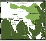
Le voyage de Yi Jing au VIIe siècle après J.- C.
|
Le moine bouddhiste chinois Yi Jing (ou I Tsing, ou I Ching) (義淨, 三藏法師義淨 635-713) vivait à l'époque de la dynastie des Tang. Son vrai nom était Zhang Wen Ming (张文明). C'est notamment par ses écrits qu'on a connaissance du royaume de Sriwijaya dans le sud de l'île indonésienne de Sumatra, d'un grand nombre de texte du bouddhisme et de l'université bouddhique de Nalanda en Inde.
..
Catégories : Moine bouddhique | Traducteur bouddhique
Wikimedia Foundation.
2010.
Contenu soumis à la licence CC-BY-SA. Source : Article I-Tsing de Wikipédia en français (auteurs)
Regardez d'autres dictionnaires:
Tsing Ma Bridge — at night Official name Tsing Ma Bridge Carries 6 lanes of roadway (upper) 2 MTR rail tracks, 2 lanes of roadway (lower) … Wikipedia
Tsing Yi Bridge — (zh tspcy|t=青衣大橋|s=青衣大桥|p=Qīngyī Dàqiáo|cy=ching1 yi1 daai6 kiu4) is the first bridge to Tsing Yi Island of Hong Kong. It crosses Rambler Channel, connecting Tsing Yi Island and Tsing Chau of Kwai Chung. The bridge spans 610 metres (about 2,000… … Wikipedia
Tsing Yi North Bridge — is also called Tsing Tsuen Bridge (Chinese: 青荃橋) which connects the Tam Kon Shan Interchange of Tsing Yi Island and Texaco Road Roundabout of Tsuen Wan, across the Rambler Channel. The bridge is built by the Japanese Firm, Maeda Co.(前田建設工業) and… … Wikipedia
Tsing Yi Peak — (zh c|c=青衣山, or Tsing I Peak formerly) or Sam Chi Heung (三支香) is a hill with three peaks occupying the southern half of the Tsing Yi Island, Hong Kong. The hill is situated on the western half of Victoria Harbour. Its peaks are good locations to… … Wikipedia
Tsing Yi Heung Sze Wui Road — (zh tspcy|t=青衣鄉事會路|s=青衣乡事会路|p=Qīngyī Xiāngshìhuì lù|cy=ching1 yi1 heung1 si6 wui2 lou6) is one of the oldest roads on the Tsing Yi Island, Hong Kong. It was built to connect Tsing Yi Town and Tsing Yi Bridge when the bridge was being built. The… … Wikipedia
Tsing Yi Bay — (zh t|t=青衣灣) was a bay at the east side of Hong Kong s Tsing Yi Island, beside Rambler Channel, which is approximately Tsing Yi Park nowadays. The whole bay was reclaimed for the development of new town. Before reclamation, it was surrounded by… … Wikipedia
Tsing Yi Pier — (Chinese: 青衣碼頭) or Tsing Yi Ferry Terminus (青衣渡輪碼頭) is a ferry pier on Tsing Yi Island, Hong Kong. It is the replacement of Tsing Yi Town old pier that was buried in reclamation.Fact|date=August 2007 There were ferries to Tsuen Wan and Central.… … Wikipedia
Tsing Yi Interchange — (Chinese: 青衣交匯處) is a road interchange on eastern Tsing Yi Island in Hong Kong, between Rambler Channel and Cheung Ching Estate.Several roads meet at the interchange: * Tsing Yi Bridge, a bridge leading to the Kwai Fong and Tsing Kwai Highway; *… … Wikipedia
Tsing Yi Police Station — (Chinese: 青衣警署), once also known as Tsing Yi Division Police Station (青衣分區警署) is the only police station on the Tsing Yi Island in Hong Kong. The station is located at Tsing Yi Heung Sze Wui Road, situated between Tsing Yi Police Married Quarters … Wikipedia
Tsing Yi Public Library — (Chinese: 青衣公共圖書館) is a public library on Tsing Yi Island, Hong Kong. It is classified as Major District / District Libraries under the system of Hong Kong Public Libraries. Before the library was established , Hong Kong Government provided the… … Wikipedia
Tsing Kwai Highway — (zh cpcy|c=青葵公路|p=Qīngkuí Gōnglù|cy=ching1 kwai4 gung1 lou6) is a section of Route 3 in Hong Kong, previously known as Route 3 Kwai Chung Section. From its junction with West Kowloon Highway at Mei Foo Roundabout, the expressway runs in the form… … Wikipedia


