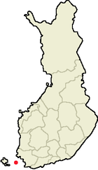
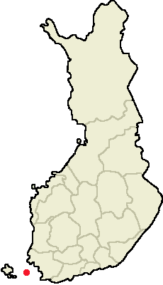
Houtskari

Houtskari

Houtskär

60° 13′ 23″ N 21° 22′ 12″ E / 60.223, 21.37

Houtskär - Houtskari
Pays
drapeau de la Finlande
     Finlande
Blason de Houtskär Localisation de Houtskär en Finlande
Province historique Finlande du Sud-Ouest
Province Finlande occidentale
Région Finlande du Sud-Ouest
Fondée en  ?
Droits de Cité non
Langue officielle bilingue suédois (88%) - finnois (11%)
Altitudes minimale : 0 m
maximale : env 40 m
Superficie
dont eau
697.18 km²
mer 576 km² + intérieures 0.65 km²
Rang
(Superficie hors eau)
379 e
Population

Rang population
655[1] hab.
(31.12.2006)
420 e
Densité 5.4 hab./km²

Houtskär (Houtskari en finnois) est une municipalité insulaire du sud-ouest de la Finlande, dans la province de Finlande occidentale et la région de Finlande du Sud-Ouest.

La commune est formée de près de 700 îles, dont seules une poignée sont habitées. On y trouve 19 villages en tout. Les îles principales sont reliées par des chaussées mais le ferry est en revanche le seul lien avec les communes voisines et le continent.

L'isolement est une des sources de l'importante baisse de la population qu'a connu la commune. Houtskär comptait encore 1 955 habitants en 1924, ils n'étaient plus que 1 066 en 1963 et à peine 650 aujourd'hui[2]. La commune continue à s'animer en été, quand arrivent les occupants des 900 maisons de vacances.

La commune comporte une très nette majorité de suédophones. La gestion de la commune est très consensuelle, le Parti populaire suédophone y a même obtenu 100% des voix aux élections municipales de 2004[3].

Les municipalités voisines, toutes au delà de bras de mer, sont Iniö au nord, Korpo à l'est et au sud, mais aussi côté Åland Kökar et Sottunga au sud-ouest et Brändö à l'ouest.

Références

Liens externes

Garages à bateaux au village de Hyppeis


Blason de la Finlande du Sud-Ouest Municipalités de Finlande du Sud-Ouest Drapeau de la Finlande

Alastaro - Askainen - Aura - Dragsfjärd - Houtskär - Iniö - Kaarina - Kimito - Korpo - Koski Tl - Kustavi - Laitila - Lemu - Lieto - Loimaa - Marttila - Masku - Mellilä - Merimasku - Mynämäki - Naantali - Nagu - Nousiainen - Oripää - Paimio - Pargas - Piikkiö - Pyhäranta - Pöytyä - Raisio - Rusko - Rymättylä - Salo - Sauvo - Somero - Taivassalo - Tarvasjoki - Turku - Uusikaupunki - Vahto - Vehmaa - Velkua - Västanfjärd - Yläne
Finlande occidentale | Finlande

  • Portail de la Finlande Portail de la Finlande
Ce document provient de « Houtsk%C3%A4r ».

Wikimedia Foundation. 2010.

Contenu soumis à la licence CC-BY-SA. Source : Article Houtskari de Wikipédia en français (auteurs)

Игры ⚽ Нужно решить контрольную?

Regardez d'autres dictionnaires:

  • Houtskari — Wappen der ehemaligen Gemeinde Houtskär Houtskär (schwedisch), finnisch Houtskari, ist eine ehemalige Gemeinde im Schärenmeer vor der Küste Südwestfinnlands. Heute gehört Houtskär zur Stadt Väståboland (Länsi Turunmaa). Das Gebiet von Houtskär… …   Deutsch Wikipedia

  • Houtskar — Houtskär 60° 13′ 23″ N 21° 22′ 12″ E / 60.223, 21.37 …   Wikipédia en Français

  • Список островов Балтийского моря — Ниже представлен список островов в Балтийском море, площадь которых превышает 10 кв. км., или население превышает 1000 чел. Балтийское море считается включающим свои заливы Финский, Ботнический, Рижский и другие. Острова, окружённые Балтийским… …   Википедия

  • List of Finnish municipalities — This is a listing in alphabetical order of the current municipalities in Finland as of 2008. For population see List of Finnish municipalities by population. Notice that if the place has both a Finnish and a Swedish name, the majority language is …   Wikipedia

  • List of Finnish municipalities by population — This is a list of the municipalities of Finland sorted by population as of 31st of December 2005:# Helsinki (Helsingfors) 560 905 {+0,3%} # Espoo (Esbo) 231 704 {+1,9%} # Tampere (Tammerfors) 204 337 {+0,7%} # Vantaa (Vanda) 187 281 {+1,0%} #… …   Wikipedia

  • List of Finnish municipalities by area — This is a list of the municipalities of Finland sorted by area as of 1st of January 2006:# 17333.38 km²: Inari (Enare) # 12415.26 km²: Sodankylä # 8391.54 km²: Enontekiö (Enontekis) # 8263.09 km²: Kittilä # 8017.20 km²: Rovaniemi # 6496.64 km²:… …   Wikipedia

  • Regions of Western Finland — This article is part of the Subdivisions of Finland series Regions Sub regions Municipalities list list by population list by area NUTS:FI ISO 3166 2:FI The former Province of Western Finland in Finland was divided on seven regions, 34 districts… …   Wikipedia

  • Houtskär — (IPA| [hu:tʃæ:r] ), or Houtskari (IPA| [ˈhoutsˌkɑri] ) in Finnish, is a municipality of Finland.It is located in the province of Western Finland and is part of the Finland Proper region. The municipality has a population of 674 (2004 12 31) and… …   Wikipedia

  • Archipelago Sea — (Finnish Saaristomeri , Swedish Skärgårdshavet ) is a part of the Baltic Sea between the Gulf of Bothnia, the Gulf of Finland and the Sea of Åland, within Finnish territorial waters. By some definitions it is the largest archipelago in the world… …   Wikipedia

  • Houtskär — Wappen der ehemaligen Gemeinde Houtskär Houtskär (schwedisch), finnisch Houtskari, ist eine ehemalige Gemeinde im Schärenmeer vor der Küste Südwestfinnlands. Heute gehört Houtskär zur Stadt Väståboland (Länsi Turunmaa). Das Gebiet von Houtskär… …   Deutsch Wikipedia

Share the article and excerpts

Direct link
Do a right-click on the link above
and select “Copy Link”