Graciosa Island
- Graciosa Island
-
Graciosa (île)

Pour les articles homonymes, voir
Graciosa.
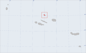
L'île de Graciosa (en portugais : Ilha da Graciosa) fait partie de l'archipel des Açores situé dans l’océan Atlantique Nord à 1400 km de Lisbonne. L'archipel est un territoire du Portugal à statut de région autonome depuis 1976.
C'est la plus septentrionale des îles du groupe central ; ses deux plus proches voisines sont l'île de São Jorge à environ 37 km au sud et l'île de Terceira à environ 57 km au sud-est.
Graciosa a été découverte après Terceira.
Géographie
L'île située a 39.02° N de latitude et 27.59° O de longitude. C'est une petite île de 8 km de long sur 4 km de large et d'une surface de 60,7 km². Son point culminant se situe à 402 m.
Elle abrite une formation volcanique rare : la Furna do Enxofre (« Caverne de soufre »), une grotte volcanique dans la caldeira.
Économie
Graciosa possède un aéroport (code AITA : GRW).
 Portail du monde maritime
 Portail du Portugal
Catégories : Volcan d'activité inconnue | Île des Açores
Wikimedia Foundation.
2010.
Contenu soumis à la licence CC-BY-SA. Source : Article Graciosa Island de Wikipédia en français (auteurs)
Regardez d'autres dictionnaires:
Graciosa Island — ▪ island, Azores, Portugal Portuguese Ilha Graciosa, volcanic island, northernmost of the central Azores, east central Atlantic Ocean. The 23 square mile (60 square kilometre) island reaches a height of 1,338 feet (408 m) at the summit… … Universalium
Graciosa, Canary Islands — Infobox Islands name = La Graciosa image caption = La Graciosa from Mirador Del Rio image size = locator locator Location map|Canary Islands|lat=29.233|long= 13.5 map custom = yes native name = native name link = nickname = location = coordinates … Wikipedia
Graciosa — There is also a Graciosa in the Canary Islands, see Graciosa, Canary Islands Infobox Islands name = Graciosa image caption = Grociosa from the air image size = locator native name = native name link = Portugal nickname = location = Atlantic Ocean … Wikipedia
Graciosa Airport — Infobox Airport name = Graciosa Airport nativename = nativename a = nativename r = image width = caption = IATA = GRW ICAO = LPGR type = Public owner = operator = ANA Aeroportos de Portugal, SA city served = location = Santa Cruz da Graciosa… … Wikipedia
Graciosa IPR — Graciosa is a Portuguese wine region centered around the island of Graciosa in the Azores. The region has the second tier Indicação de Proveniencia Regulamentada (IPR) classification and may some day be promoted to Denominação de Origem… … Wikipedia
Santa Cruz da Graciosa — Infobox Municipality pt official name = Santa Cruz da Graciosa image coat of arms = SCG.png Region = A.R. of Azores Subregion = A.R. of Azores District = A.R. of Azores Mayor name = José Ramos Aguiar Mayor party = PSD area total = 60.7 population … Wikipedia
São Jorge Island — ▪ island, Portugal Portuguese Ilha De São Jorge volcanic island of the central Azores, east central North Atlantic. Lying 35 miles (56 km) south of the island of Graciosa, the island measures 36 by 4 miles (58 by 6 km) and has an area of… … Universalium
Corvo Island — This article is about the island. For the municipality, see Corvo, Azores. Corvo Island (Ilha) The island of Corvo as seen f … Wikipedia
Newfoundland (island) — This article is about the island in the North Atlantic Ocean. For the Canadian province of which it is a part, see Newfoundland and Labrador. For other uses, see Newfoundland (disambiguation). Newfoundland … Wikipedia
Faial Island — Infobox Islands name = Faial image caption = image size = locator native name = native name link = Portugal nickname = Ilha Azul location = Atlantic Ocean coordinates = archipelago = Azores Islands area = 173 km² highest mount = Cabeço Gordo… … Wikipedia
 Portugal