Geotagging
- Geotagging
-
Géotag
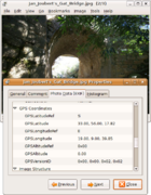
Un géotag est un marqueur (« tag », en anglais) à caractère géographique inséré dans des fichiers audio ou raster dans champs EXIF (JPEG, TIFF, RIFF), IPCT (JPEG/TIFF), XMP (très nombreux formats). En français, on parle de « balise de géolocalisation ».
Cette balise peut notamment contenir :
- des données GPS (coordonnées latitude et longitude, une altitude)
- des informations saisie par l'utilisateur : lieux de saisie, code postal...
D'autres données non cartographique peuvent être associé comme :
- des données temporelles : heure de capture...
- des données spécifiques aux périphériques de capture : appareil photo (focale...), appareil audio (échantillonnage, bit...)
Voir aussi
Liens externes
 Portail de l’information géographique
Wikimedia Foundation.
2010.
Contenu soumis à la licence CC-BY-SA. Source : Article Geotagging de Wikipédia en français (auteurs)
Regardez d'autres dictionnaires:
Geotagging — is the process of adding geographical identification metadata to various media such as photographs, video, websites, or RSS feeds and is a form of geospatial metadata. This data usually consists of latitude and longitude coordinates, though it… … Wikipedia
Geotagging — Unter dem Vorgang der Georeferenzierung, Geokodierung oder Verortung versteht man die Zuweisung raumbezogener Referenzinformationen, der Georeferenz, zu einem Datensatz. Der Vorgang spielt eine wichtige Rolle in der Computerkartografie,… … Deutsch Wikipedia
geotagging — pp. Embedding the current geographical location within digital media, particularly photos and videos. Also: geo tagging. Example Citations: For example, on Helio s Fin phone, you can automatically tag your pictures with G.P.S. coordinates… … New words
Geotagging (Fotografie) — Track mit georeferenzierten Bildern Unter Geotagging, auch Geocoding oder Geo Imaging, versteht man bei fotografischen Aufnahmen die Zuordnung von geographischen Koordinaten. Als Punkte in einer elektronischen Karte lassen sich die so… … Deutsch Wikipedia
Géotagging — Géotag Visualisation de l information géographique d une photo JPEG avec le logiciel libre gThumb. Un géotag est un marqueur (« tag », en anglais) à caractère géographique inséré dans des fichiers audio ou raster dans champs EXIF (JPEG … Wikipédia en Français
Auto-geotagging — or automatic geotagging was first coined [cite news last = London first = Bill title = Sharing the Location of a favorite Place: That s GeoMonkey Business work = WSU Today date = 2007 12 14 url = http://www.wsutoday.wsu.edu/pages/Publications.asp?… … Wikipedia
Comparison of smartphones — Main article: smartphone Contents 1 Hardware and OS 2 Networks and connectivity 3 See also 4 References … Wikipedia
Distributed GIS — concerns itself with GI Systems that do not have all of the system components in the same physical location. This could be the processing, the database, the rendering or the user interface. Examples of distributed systems are web based GIS,… … Wikipedia
MapWith.Us — is a geosocial networking website that allows users to create and share custom maps with an online community. User maps are created by uploading and geotagging media. When media is associated with a location on a map, the media is known as a map… … Wikipedia
Geo tagging — Unter dem Vorgang der Georeferenzierung, Geokodierung oder Verortung versteht man die Zuweisung raumbezogener Referenzinformationen, der Georeferenz, zu einem Datensatz. Der Vorgang spielt eine wichtige Rolle in der Computerkartografie,… … Deutsch Wikipedia