District de Haa
- District de Haa
-
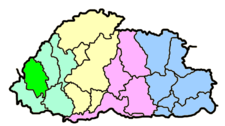
Haa
Haa est l'un des 20 dzongkhags qui constituent le Bhoutan.
 Portail du monde indien
Catégorie : District du Bhoutan
Wikimedia Foundation.
2010.
Contenu soumis à la licence CC-BY-SA. Source : Article District de Haa de Wikipédia en français (auteurs)
Regardez d'autres dictionnaires:
Haa District — This page is about the area Haa. For information about the airships, please see high altitude airship. Haa ཧཱ་རྫོང་ཁག་ (alternative spellings Ha ) one of the 20 dzongkhag or districts comprising Bhutan. Per the 2005 census, the population of Haa… … Wikipedia
Haa — 27°15′N 89°10′E / 27.25, 89.167 ཧྭ (hw … Wikipédia en Français
8 (Belfast) HAA Regiment Royal Artillery — The 8th (Belfast) Heavy Anti Aircraft Regiment, Royal Artillery (Supplementary Reserve), was founded in the wake of the Munich crisis, and recruited mainly in the spring of 1939 from young men of the City and District of Belfast. It was mobilised … Wikipedia
Sangrur district — Infobox Indian Jurisdiction native name = Sangrur | type = district| latd = 30.23 | longd = 75.83 locator position = right | state name = Punjab district = Sangrur district leader title = leader name = altitude = 232 population as of = 2001… … Wikipedia
Chukha District — Coordinates: 27°0′N 89°30′E / 27°N 89.5°E / 27; 89.5 … Wikipedia
Dagana District — Coordinates: 27°0′N 89°55′E / 27°N 89.917°E / 27; 89.917 … Wikipedia
Tsirang District — Coordinates: 26°55′N 90°5′E / 26.917°N 90.083°E / 26.917; 90.083 … Wikipedia
Samtse District — Samtseབསམ་རྩེ་རྫོང་ཁག་ (older spelling Samchi), is one of the 20 dzongkhag (districts) comprising Bhutan. History and cultureHistorically, Samstse was sparsely populated as the mountain dwelling Bhutanese considered the low lying district to be… … Wikipedia
Thimphou (District) — 27°35′N 89°35′E / 27.583, 89.583 ཐ … Wikipédia en Français
Paro District — Paro (Dzongkha: dz. སྤ་རོ་རྫོང་ཁག) is the name of a district ( dzongkhag ), valley, river and town (population 20,000) in the Kingdom of Bhutan. It is one of the most historic valleys in Bhutan. Both trade goods and invading Tibetans came over… … Wikipedia