Dere Street
Contenu soumis à la licence CC-BY-SA. Source : Article Dere Street de Wikipédia en français (auteurs)
Regardez d'autres dictionnaires:
Dere Street — Route of Dere Street in blue Route information Length: 226 mi (364 km) [146 mi (235 km) Eboracum to … Wikipedia
Dere Street — Roman road from Lincoln, via York, to the Antonine Wall near Edinburgh … Medieval glossary
Deere Street — Dere Street Les principales voies romaines de Bretagne ; Dere Street est en bleu. Dere Street ou Deere Street est une voie romaine qui reliait York (Eboracum) au mur d Antonin. Ce document provient de « Dere Street » … Wikipédia en Français
Watling Street — La moderna Watling Street atravesando Rochester cerca de pasos romanos y celtas. Watling Street es el nombre dado a una antigua vía situada entre Inglaterra y Gales. Los primeros que la usaron fueron los Celtas, entre las modernas ciudades de… … Wikipedia Español
66th Street (Manhattan) — 66th Street is a crosstown street in the New York City borough of Manhattan with portions on the Upper East Side and Upper West Side connected across Central Park via the 65th Street Transverse. West 66th Street is the location of the historical… … Wikipedia
Crailinghall — Dere Street at Crailinghall Crailinghall is a village near Oxnam in the Scottish Borders area of Scotland, in the former Roxburghshire. Crailinghall is on the route of the St. Cuthbert s Way and the Roman Heritage Way. See also … Wikipedia
Cliffe, Richmondshire — For the other village of the same name in North Yorkshire, see Cliffe, Selby. Cliffe George Hotel at Cliffe Population 1,447 OS … Wikipedia
Devil's Causeway — Coordinates: 55°18′29″N 1°48′32″W / 55.308°N 1.809°W / 55.308; 1.809 … Wikipedia
Vindomora — (or Ebchester Roman Fort) was an auxiliary castra on Dere Street, in the Roman province of Britannia Inferior (Upper Britain The Romans judged distances by proximity to Rome, therefore north england is inferior as it is farther away). Its ruins… … Wikipedia
Longovicium — (or Lanchester Roman Fort) was an auxiliary castra on Dere Street, in the Roman province of Britannia Inferior (Upper Britain The Romans judged distances by proximity to Rome, therefore north England is inferior as it is farther away). Its ruins… … Wikipedia
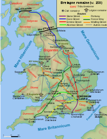 Les principales voies romaines de Bretagne ; Dere Street est en bleu.
