- County Down
-
Comté de Down
 Pour les articles homonymes, voir Down.
Comté de Down
Contae An Dúin[[Image: |175px|Drapeau de Comté de Down]] 
 WGS-84 (GPS) Coordinates:
[{{{Coor URL}}}{{{north coord}}}_N_{{{west coord}}}_W_{{{region:IE_type:city}}} {{{north coord}}}° N {{{west coord}}}° W]Irish Grid Reference
grid}}} {{{irish grid}}}Statistiques Province: Ulster District: Capitale: Downpatrick Code: Superficie: 1 704 km² Altitude: Population
(2006):454000 hab -Town:
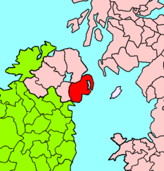
-Rural:Site web: [http:// ] Le Comté de Down (en gaélique Contae An Dúin) est un des six Comtés qui forme l’Irlande du Nord. Il fait partie de la province d’Ulster. Sa superficie est de 2448 km² pour près de 454 000 habitants. Sa capitale est Downpatrick. C’est à l’intérieur du Comté que l’on trouve le point le plus à l’est de l’île d’Irlande (Burr Point). Le Comté est entouré des Comté d’Antrim au nord, d’Armagh à l’ouest et par la mer d'Irlande à l’est.
les villes du Comté
- Annalong, Ardglass
- Ballynahinch, Banbridge, Bangor
- Carryduff, Clough, Comber, Crossgar
- Donaghadee, Downpatrick, Dromore, Dundonald
- Gilford
- Hillsborough, Holywood
- Kilkeel, Killinchy, Killyleagh
- Lawrencestown, Loughinisland,
- Millisle
- Newcastle, Newry, Newtownards
- Portaferry
- Rostrevor
- Saintfield, Saul, Seaforde, Shrigley, Strangford, Strangford Lough
- Warrenpoint
- Monkstown
Comtés d'Irlande 
Connacht: Galway (~Ville) | Leitrim | Mayo | Roscommon | Sligo Munster: Clare | Cork (~Ville) | Kerry | Limerick (~Ville) | Tipperary (Nord~; Sud~) | Waterford (~Ville) Leinster: Carlow | Dublin (~Ville; Dun Laoghaire-Rathdown; Fingal; Sud~) | Kildare | Kilkenny | Laois | Longford | Louth | Meath | Offaly | Westmeath | Wexford | Wicklow Ulster: Antrim * | Armagh * | Cavan | Donegal | Down * | Fermanagh * | Londonderry * | Monaghan | Tyrone *
* indique les comtés d'Irlande du Nord (les autres font partie de l'État d'Irlande); l'italique indique un comté non administratif; les (parenthèses) indiquent un comté non-traditionnel. Portail de l’Irlande
 Portail du Royaume-Uni
Catégories : Ulster | Comté de l'Irlande du Nord

Wikimedia Foundation. 2010.