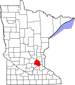
- Comté de Hennepin
-
Comté de Hennepin
(Hennepin County)
Administration Pays  États-Unis
État  Minnesota
Chef-lieu Minneapolis Fondation 6 mars 1852 Superficie Totale 1 571 km² Terre 1 442 km² Eau 129 km² (8,21 %) Population Totale (recens. 2000) 1 116 200 hab. Densité 774,06 hab./km² Le comté de Hennepin est un comté de l'État du Minnesota, aux États-Unis. Il comptait 1 116 200 habitants en 2000. Son siège est Minneapolis, nommé ainsi en l'honneur de l'explorateur belge (originaire d'Ath) du XVIIe siècle Louis Hennepin.
Sommaire
Géographie
Les comtés adjacents :
- Comté d'Anoka (nord-est)
- Comté de Ramsey (est)
- Comté de Dakota (sud-est)
- Comté de Scott(sud)
- Comté de Carver (sud-ouest)
- Comté de Wright (nord-ouest)
Transport
Principales routes
 Interstate 35W
 Interstate 94
 Interstate 394
 Interstate 494
 Interstate 694
 U.S. Route 12
 U.S. Route 52
 U.S. Route 169
 U.S. Route 212
- Minnesota State Highway 5
- Minnesota State Highway 7
- Minnesota State Highway 47
- Minnesota State Highway 55
- Minnesota State Highway 62
- Minnesota State Highway 65
- Minnesota State Highway 77
- Minnesota State Highway 100
- Minnesota State Highway 101
- Minnesota State Highway 121
- Minnesota State Highway 312
- Minnesota State Highway 252
- Minnesota State Highway 280
- Minnesota State Highway 610
Principales villes
- Bloomington
- Brooklyn Center
- Brooklyn Park
- Champlin
- Chanhassen
- Corcoran
- Crystal
- Dayton
- Deephaven
- Eden Prairie
- Edina
- Excelsior
- Golden Valley
- Greenfield
- Greenwood
- Hanover‡
- Hopkins
- Independence
- Long Lake
- Loretto
- Maple Grove
- Maple Plain
- Medicine Lake
- Medina
- Minneapolis
- Minnetonka
- Minnetonka Beach
- Minnetrista
- Mound
- New Hope
- Orono
- Osseo
- Plymouth
- Richfield
- Robbinsdale
- Rockford
- Rogers
- Shorewood
- Spring Park
- St. Anthony Village
- St. Bonifacius
- St. Louis Park
- Tonka Bay
- Wayzata
- Woodland
Voir aussi
Lien externe
- (en) Site du comté
Wikimedia Foundation. 2010.

