Abel Tasman National Park
- Abel Tasman National Park
-
Parc national Abel Tasman
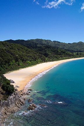
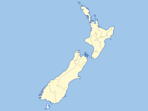
Le parc national Abel Tasman est un parc national situé sur la pointe nord-ouest de île du Sud de la Nouvelle-Zélande. Fondé en 1942, il est le plus petit des parcs nationaux du pays, à seulement 225 km² de superficie. Il est nommé en honneur de l'explorateur Abel Tasman, qui devient en 1642 le premier Européen à voir la Nouvelle-Zélande.
Il consiste en paysages légèrement accidentés au nord des vallées des fleuves Takaka et Riwaka ; au nord il est cerné par les eaux des baies Golden et Tasman. Une partie de la côte sablonneuse est une « réserve scénique » (« Scenic Reserve »), recouvrant 774 hectares (soit environ 70 km de côte).
Le Department of Conservation régit le parc et la réserve scénique est régie par le Tasman District Council. Toute activité se déroulant dans les eaux de la côte tombe sous sa responsabilité. Le parc et la réserve sont sous des règlements différents.
L' Abel Tasman Coast Track est un chemin très prisé des personnes faisant du trekking ; il suit les méandres de la côte. L' Abel Tasman Inland Track, parcourant l'intérieur, est moins fréquenté.
La ville la plus proche est Motueka, à 20 km au nord.
Notes et références
 Portail de la conservation de la nature
 Portail de la Nouvelle-Zélande
Catégories : Aire protégée de l'UICN - catégorie II | Parc national de Nouvelle-Zélande | Aire protégée créée en 1942 | Tasman
Wikimedia Foundation.
2010.
Contenu soumis à la licence CC-BY-SA. Source : Article Abel Tasman National Park de Wikipédia en français (auteurs)
Regardez d'autres dictionnaires:
Abel Tasman National Park — ▪ park, New Zealand wildlife preserve in northwestern South Island, New Zealand. Established in 1942, it was named for Abel Tasman, the Dutch navigator. With an area of 55,699 acres (22,541 hectares), it extends inland for about 6 miles (10 … Universalium
Abel Tasman National Park — Infobox protected area name = Abel Tasman National Park iucn category = II caption = Map of New Zealand locator x = 147 locator y = 102 location = Tasman District, New Zealand nearest city = Motueka lat degrees = 40 lat minutes = 50 lat seconds … Wikipedia
Abel Tasman National Park — Daten und Fakten Gründung: 1942 Lage: Neuseeland Südinsel Höhenlage: 0 bis 1.150 m ü. NN Fläche: 225,3 km² … Deutsch Wikipedia
Abel Tasman National Park — /eɪbəl ˈtæzmən/ (say aybuhl tazmuhn) noun a national park of NZ, in the north west of the South Island. 17 593 ha …
Tasman National Park — Tasman Nationalpark ist der Name von Tasman Nationalpark (Australien) Abel Tasman Nationalpark in Neuseeland … Deutsch Wikipedia
Abel Tasman — Abel Janszoon Tasman (1603 October 10 1659), was a Dutch seafarer, explorer, and merchant.Tasman is best known for his voyages of 1642 and 1644 in the service of the VOC United East India Company). He was the first known European expedition to… … Wikipedia
Abel-Tasman-Nationalpark — Ein Küstenabschnitt im Abel Tasman Nationalpark … Deutsch Wikipedia
Abel Tasman — Abel Tasman, Ausschnitt aus einem Gemälde von Jacob Cuyp, 1637 Abel Janszoon Tasman (* 1603 in Lutjegast, Provinz Groningen; † 10. Oktober 1659 in Batavia, Java) war ein niederländischer Seefahrer. Auf seinen Entdeckungsreisen umsegelte er den… … Deutsch Wikipedia
Abel Tasman Coast Track — The Abel Tasman Coast Track is a 51km (32 mile) long New Zealand walking track within the Abel Tasman National Park. It extends from Marahau in the south to Wainui in the north, with many optional side tracks. It is one of two main tracks through … Wikipedia
Abel Tasman Inland Track — The Abel Tasman Inland Track is a 38 km tramping track that runs through the centre of the Abel Tasman National Park and is maintained by the Department of Conservation. It diverts from the main Abel Tasman Coast Track between Tinline Bay and… … Wikipedia


