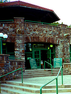
Cave and Basin
- Cave and Basin
-
Cave and Basin est un lieu historique national du Canada est situé dans la ville de Banff, en Alberta, sur le site de sources sulfureuses naturelles autour de laquelle le parc national de Banff a été créé.
James Hector de l'Expédition Palliser en 1859 est le premier à signaler ces sources thermales. Trois ouvriers travaillant pour le Chemin de fer Canadien Pacifique en 1883 ainsi que d'autres requérants, se disputent obtenir pour les droits de propriété des sources thermales .
Une enquête du tribunal gouvernemental suivit et le gouvernement du Canada dirigé par le Premier ministre John A. Macdonald décide de transformer en réserve et zones protégées les 26 kilomètres carrés englobant toutes les sources minérales thermales.
Aujourd'hui, Cave and Basin est reconnu à juste titre comme le berceau des parcs nationaux du Canada.
Les sources chaudes de Cave and Basin sont également un habitat riche. Des bactéries, des algues, des petits poissons et des insectes prospèrent dans les eaux thermales. On peut y voir également des orchidées. C'est aussi l'habitat de la physe des fontaines de Banff (Physella johnsoni), une espèce d'escargot menacée d'extinction[1].
Notes et références
Wikimedia Foundation.
2010.
Contenu soumis à la licence CC-BY-SA. Source : Article Cave and Basin de Wikipédia en français (auteurs)
Regardez d'autres dictionnaires:
Cave and Basin National Historic Site — The Cave and Basin National Historic Site of Canada is located in the town of Banff, Alberta, at the site of natural sulphurous springs around which Banff National Park was first established. James Hector of the Palliser Expedition of 1859 first… … Wikipedia
Cave and Bassin — Cave and Basin Cave and Basin est un lieu historique national du Canada est situé dans la ville de Banff, en Alberta, sur le site de sources sulfureuses naturelles autour de laquelle le parc national de Banff a été créé. James Hector de l… … Wikipédia en Français
cave — cavelike, adj. /kayv/, n., v., caved, caving. n. 1. a hollow in the earth, esp. one opening more or less horizontally into a hill, mountain, etc. 2. a storage cellar, esp. for wine. 3. Eng. Hist. a secession, or a group of seceders, from a… … Universalium
Cave of the Mounds — The Cave of the Mounds is a natural limestone cave located in Blue Mounds, Wisconsin, USA, and is named for two nearby hills called the Blue Mounds. More specifically, it is located in the southern slope of the east hill. The cave s beauty comes… … Wikipedia
Close To The Edge Provincial Park and Protected Area — is a provincial park and a protected area in British Columbia, Canada. Contents 1 History and conservation 2 Location 3 Size 4 … Wikipedia
Anthropology and Archaeology — ▪ 2009 Introduction Anthropology Among the key developments in 2008 in the field of physical anthropology was the discovery by a large interdisciplinary team of Spanish and American scientists in northern Spain of a partial mandible (lower… … Universalium
Mammoth Cave National Park — Mammoth Cave redirects here. For other uses, see Mammoth Cave (disambiguation). Mammoth Cave National Park IUCN Category II (National Park) The Rotund … Wikipedia
Craters of the Moon National Monument and Preserve — For other uses, see Craters of the Moon (disambiguation). Craters of the Moon National Monument and Preserve IUCN Category III (Natural Monument) … Wikipedia
Onondaga Cave State Park — Coordinates: 38°3′40″N 91°13′38″W / 38.06111°N 91.22722°W / 38.06111; 91.22722 … Wikipedia
Northern Basin and Range (ecoregion) — The Northern Basin and Range ecoregion is a Level III ecoregion designated by the United States Environmental Protection Agency (EPA) in the U.S. states of Oregon, Idaho, Nevada, Utah, and California. It contains dissected lava plains, rolling… … Wikipedia
 Canada
 Alberta


