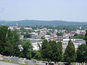
Boyertown

Boyertown

40° 19′ 53″ N 75° 38′ 10″ W / 40.331389, -75.636111

Boyertown
Image illustrative de l'article Boyertown
Administration
Pays Drapeau des États-Unis États-Unis
État Drapeau de la Pennsylvanie Pennsylvanie
Comté Berks
Démographie
Population (2000) 3 940 hab.
Densité 1 876 hab./km²
Géographie
Coordonnées 40° 19′ 53″ Nord
       75° 38′ 10″ Ouest
/ 40.331389, -75.636111
Superficie totale 2,1 km2
· dont terre 2,1 km2 (100 %)
· dont eau 0 km2 (0 %)
Fuseau horaire EST (UTC-5)
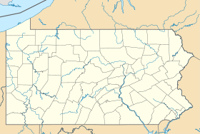
Voir la carte administrative
City locator 14.svg
Voir la carte topographique
City locator 14.svg

Boyertown est un borough américain situé dans le comté de Berks, en Pennsylvanie. Selon le recensement de 2000, sa population s’élève à 3 940 habitants. Superficie totale : 2,1 km² (0,8 mi²). Densité : 909,8 hab/km² (2 364,2 hab/mi²). Coordonnées géographiques : 40°19′53″N 75°38′10″O / 40.33139, -75.63611.

Jumelage

Drapeau : Ukraine Bohodoukhiv (Ukraine)

Drapeau de Pennsylvanie
Commonwealth de Pennsylvanie
Harrisburg (capitale)
Matières

Villes | Boroughs | Townships | Gouvernement | Histoire | Pennsylvaniens | Parcs d'État

Zones
métropolitaines

Allentown-Bethlehem-Easton | Altoona | Érié | Harrisburg–Carlisle–Lebanon | Johnstown | Lancaster | Philadelphie | Pittsburgh | Reading | Scranton-Wilkes-Barre | State College | Williamsport | York-Hanover

Régions

Forêt nationale d'Allegheny | Montagnes sans fin | Montagnes de Laurel | Pays néerlandais | Pennsylvanie du nord-est | Pennsylvanie occidentale | Poconos | Rangée Nordique | Région du charbon | Région des Montagnes de Pennsylvanie | Région du nord-ouest | Vallée de Cumberland | Vallée de Lehigh | Vallée du Delaware | Vallée du Susquehanna | Vallée du Wyoming | Vallée heureuse

Comtés

Adams | Allegheny | Armstrong | Beaver | Bedford | Berks | Blair | Bradford | Bucks | Butler | Cambria | Cameron | Carbon | Centre | Chester | Clarion | Clearfield | Clinton | Columbia | Crawford | Cumberland | Dauphin | Delaware | Elk | Érié | Fayette | Forest | Franklin | Fulton | Greene | Huntingdon | Indiana | Jefferson | Juniata | Lackawanna | Lancaster | Lawrence | Lebanon | Lehigh | Luzerne | Lycoming | McKean | Mercer | Mifflin | Monroe | Montgomery | Montour | Northampton | Northumberland | Perry | Philadelphie | Pike | Potter | Schuylkill | Snyder | Somerset | Sullivan | Susquehanna | Tioga | Union | Venango | Warren | Washington | Wayne | Westmoreland | Wyoming | York


Wikimedia Foundation. 2010.

Contenu soumis à la licence CC-BY-SA. Source : Article Boyertown de Wikipédia en français (auteurs)

Игры ⚽ Нужно решить контрольную?

Regardez d'autres dictionnaires:

  • Boyertown — Boyertown, PA U.S. borough in Pennsylvania Population (2000): 3940 Housing Units (2000): 1885 Land area (2000): 0.797293 sq. miles (2.064980 sq. km) Water area (2000): 0.000000 sq. miles (0.000000 sq. km) Total area (2000): 0.797293 sq. miles… …   StarDict's U.S. Gazetteer Places

  • Boyertown, PA — U.S. borough in Pennsylvania Population (2000): 3940 Housing Units (2000): 1885 Land area (2000): 0.797293 sq. miles (2.064980 sq. km) Water area (2000): 0.000000 sq. miles (0.000000 sq. km) Total area (2000): 0.797293 sq. miles (2.064980 sq. km) …   StarDict's U.S. Gazetteer Places

  • Boyertown — Original name in latin Boyertown Name in other language State code US Continent/City America/New York longitude 40.33371 latitude 75.63741 altitude 129 Population 4055 Date 2011 05 14 …   Cities with a population over 1000 database

  • Boyertown Area School District — Infobox School name = Boyertown Area School District location = Berks County and Montgomery County, Pennsylvania country = United States schoolboard = superintendent = Harry W. Morgan faculty = 424.7 (on FTE basis)… …   Wikipedia

  • Boyertown, Pennsylvania — Geobox Borough name = Borough of Boyertown native name = other name = other name1 = category = Borough image size = image caption = Boyertown viewed from atop Cannon Hill flag size = symbol = symbol size = country = United States state =… …   Wikipedia

  • 19512 — Boyertown, Pa (Miscellaneous » ZIP Codes) …   Abbreviations dictionary

  • Rhoads Opera House — The Rhoads Opera House, located in Boyertown, Pennsylvania, caught fire on January 13 1908 during a church sponsored stage play. The fire started when a kerosene lamp was knocked over, lighting gasoline from a stereoscopic machine. The stage and… …   Wikipedia

  • Hhrbl — The Helping Hands Recreational Baseball League, more commonly known as HHRBL, is an amateur baseball league headquartered in Barto, Pennsylvania. The league has more than 60 chartered members aged 16 to 24, and stages games on weekday evenings… …   Wikipedia

  • Pennsylvania Route 562 — PA Route 562 Route information Maintained by PennDOT Length: 14 mi (23 km) …   Wikipedia

  • Berks County, Pennsylvania — Reading skyline …   Wikipedia

Share the article and excerpts

Direct link
Do a right-click on the link above
and select “Copy Link”