Wilhelmsfeld

Wilhelmsfeld
Wilhelmsfeld
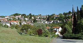
Image illustrative de l'article Wilhelmsfeld
Blason de Wilhelmsfeld
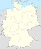
Germany location map.svg
Wilhelmsfeld
Administration
Toponyme officiel
Pays Drapeau d'Allemagne Allemagne
Land Flag of Baden-Württemberg.svg Bade-Wurtemberg
District
(Regierungsbezirk)
District de Karlsruhe
Arrondissement
(Landkreis)
Arrondissement de Rhin-Neckar
Code communal
(Gemeindeschlüssel)
08 2 26 099
Code postal 69259
Indicatif téléphonique 06220
Immatriculation HD
Site web www.wilhelmsfeld.de
Politique 2009-2014
Bourgmestre
(Bürgermeister)
Hans Zellner
Partis au pouvoir
Géographie
Coordonnées 49° 28′ 18″ N 8° 45′ 20″ E / 49.47166667, 8.7555555649° 28′ 18″ Nord
       8° 45′ 20″ Est
/ 49.47166667, 8.75555556
  
Altitude (NN) 280 - 530 m
Superficie 4.75 km2
Démographie
Population 3223 hab. (2009-12-31)
Densité 679 hab./km2


Wilhelmsfeld est une commune de Bade-Wurtemberg (Allemagne), située dans l'arrondissement de Rhin-Neckar, dans l'aire urbaine Rhin-Neckar, dans le district de Karlsruhe.


Wikimedia Foundation. 2010.

Contenu soumis à la licence CC-BY-SA. Source : Article Wilhelmsfeld de Wikipédia en français (auteurs)

Игры ⚽ Поможем сделать НИР

Regardez d'autres dictionnaires:

  • Wilhelmsfeld — Wilhelmsfeld, früher großes Moos bei Langenau 1); jetzt angebaut …   Pierer's Universal-Lexikon

  • Wilhelmsfeld — Wappen Deutschlandkarte …   Deutsch Wikipedia

  • Wilhelmsfeld — Infobox German Location Name = German name = Art = Municipality image photo = imagesize = image caption = Wappen = Wappen Wilhelmsfeld.png Wappengröße = lat deg = 49 | lat min = 28 | lat sec = 18 lon deg = 08 | lon min = 45 | lon sec = 20 Karte …   Wikipedia

  • Wilhelmsfeld — Original name in latin Wilhelmsfeld Name in other language State code DE Continent/City Europe/Berlin longitude 49.47056 latitude 8.75361 altitude 440 Population 3433 Date 2011 04 25 …   Cities with a population over 1000 database

  • Liste der Orte im Rhein-Neckar-Kreis — Die Liste der Orte im Rhein Neckar Kreis listet die geographisch getrennten Orte (Ortsteile, Stadtteile, Dörfer, Weiler, Höfe, (Einzel )Häuser) im Rhein Neckar Kreis auf.[1] Systematische Liste Alphabet der Städte und Gemeinden mit den… …   Deutsch Wikipedia

  • José Rizal — This article is about the Philippine national hero. For other uses, see José Rizal (disambiguation). José Protacio Rizal Mercado y Alonzo Realonda José Rizal, the national hero of the Philippines. Born June 19, 1861 Calamba City, Laguna …   Wikipedia

  • Altneudorf — Wappen Deutschlandkarte …   Deutsch Wikipedia

  • Kringelsdorf — Krynhelecy Gemeinde Boxberg/O.L. Koordinaten …   Deutsch Wikipedia

  • Schönau (Odenwald) — Wappen Deutschlandkarte …   Deutsch Wikipedia

  • Teltschikturm — Der Teltschikturm ist ein 41 Meter hoher …   Deutsch Wikipedia

Share the article and excerpts

Direct link
Do a right-click on the link above
and select “Copy Link”