Walkerburn
Contenu soumis à la licence CC-BY-SA. Source : Article Walkerburn de Wikipédia en français (auteurs)
Regardez d'autres dictionnaires:
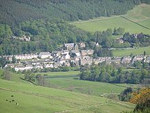
Walkerburn — is a small village in the Scottish Borders.It sits on the A72 around eight miles from Peebles and ten miles from Galashiels.Founded in 1854 around the mill to house the workers, Walkerburn now has a population of around 660.ee also*Walkerburn… … Wikipedia
Walkerburn RFC — Infobox esl club | clubname = Walkerburn RFC fullname = Walkerburn Rugby Football Club emblem = SRFC on Blue background colours = Red and Black founded = 1884 sport = Rugby union league = Edinburgh and District League ground = Caberston Haugh web … Wikipedia
Scottish Borders — infobox Scotland council area Council= Scottish Borders SizeRank= 6th Size= 4,732 km² Water= ? AdminHQ= Newtown St. Boswells ISO= GB SCB ONS= 00QE PopulationRank= 18th PopulationDate= 2004 Population= 109,270 PopulationDensity=23 / km²… … Wikipedia
Melrose, Scottish Borders — Coordinates: 55°35′53″N 2°43′52″W / 55.598°N 2.731°W / 55.598; 2.731 … Wikipedia
Coldstream — For other places with the same name, see Coldstream (disambiguation). Coordinates: 55°39′05″N 2°15′15″W / 55.65147°N 2.25423°W / … Wikipedia
List of postcode districts in the United Kingdom — This is a list of postcode districts in the United Kingdom. A group of postcode districts with the same alphabetical prefix is called a postcode area. All, or part, of one or more postcode districts are grouped into post towns.[1] Contents 1 List … Wikipedia
Coldstream Bridge — Coordinates: 55°39′14″N 2°14′31″W / 55.654°N 2.242°W / 55.654; 2.242 … Wikipedia
Dryburgh Bridge — Dryburgh Suspension Bridge Dryburgh Bridge refers to two different footbridges erected near Dryburgh Abbey, Borders, Scotland, between the villages of Dryburgh and St. Boswells (part of a ribbon of settlements including Newtown … Wikipedia
List of Church of Scotland parishes — The Church of Scotland, the national church of Scotland, divides the country into presbyteries, which are subdivided into parishes, each served by a parish church, usually with its own minister. Unions and readjustments may however result in a… … Wikipedia
Border League — Infobox sports league logo= pixels=250px caption= sport=Rugby union founded=1901 teams=10 country=SCO champion=Selkirk RFC For the defunct baseball league, see Border League (baseball) The Border League, is the oldest established rugby union… … Wikipedia
 Walkerburn
