Uličské Krivé
- Uličské Krivé
-
Uličské Krivé est un village de Slovaquie situé dans la région de Prešov.
Histoire
Première mention écrite du village en 1478.
Notes et références
Catégories :
- Village de Slovaquie
- Village et ville du district de Snina
Wikimedia Foundation.
2010.
Contenu soumis à la licence CC-BY-SA. Source : Article Uličské Krivé de Wikipédia en français (auteurs)
Regardez d'autres dictionnaires:
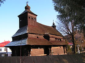
Uličské Krivé — Geobox|Settlement name = Uličské Krivé category = Village etymology = official name = motto = nickname = image caption = Wooden church ( cerkva ) in Uličské Krivé symbol = symbol type = country = Slovakia country state = region = Prešov Region… … Wikipedia
Poloniny National Park — A typical polonina meadow … Wikipedia
Liste der Städte und Gemeinden in der Slowakei/S-Ž — Übersicht S bis Ž Teil 1 A bis G Teil 2 H bis Ľ Teil 3 M bis R Teil 4 S bis Ž Übersicht S Š T Ť U V Z Ž S … Deutsch Wikipedia
Liste der Städte und Gemeinden in der Slowakei Teil 4 — Übersicht S bis Ž Teil 1 A bis G Teil 2 H bis Ľ Teil 3 M bis R Teil 4 S bis Ž Übersicht S Š T Ť U V Z Ž S … Deutsch Wikipedia
Snina — Geobox|Settlement name = Snina category = Town etymology = official name = motto = nickname = image caption = View of Snina with Vihorlat Mts. in the background symbol = Coat of arms of Snina.png symbol type = country = Slovakia country state =… … Wikipedia
Snina District — District Country Slovakia Region (kraj … Wikipedia
Nová Sedlica — Location of Snina District in the Prešov Region. Nová Sedlica (Hungarian: Újszék, Ukrainian: Новоселиця (Novoselytsia)) is the easternmost village and municipality in Slovakia (the most eastern point is the Kremenec Mountain), in Snina District… … Wikipedia
Dlhé nad Cirochou — Location of Snina District in the Prešov Region. Dlhé nad Cirochou is a village and municipality in Snina District in the Prešov Region of north eastern Slovakia. History In historical records the village … Wikipedia
Čukalovce — Location of Snina District in the Prešov Region. Čukalovce is a village and municipality in Snina District in the Prešov Region of north eastern Slovakia. History In historical records the … Wikipedia
Dúbrava, Snina District — Location of Snina District in the Prešov Region. Dúbrava is a village and municipality in Snina District in the Prešov Region of north eastern Slovakia. History In historical records the … Wikipedia
 Slovaquie
 Uličské Krivé