Jalová
- Jalová
-
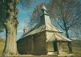
Jalová est un village de Slovaquie situé dans la région de Prešov.
Histoire
Première mention écrite du village en 1568.
Notes et références
Catégories :
- Village de Slovaquie
- Village et ville du district de Snina
Wikimedia Foundation.
2010.
Contenu soumis à la licence CC-BY-SA. Source : Article Jalová de Wikipédia en français (auteurs)
Regardez d'autres dictionnaires:
Jalová — is a village and municipality in Snina District in the Prešov Region of north eastern Slovakia.HistoryIn historical records the village was first mentioned in 1568.GeographyThe municipality lies at an altitude of 350 metres and covers an area of… … Wikipedia
jálov — a o prid. (á) 1. ki ne more imeti potomcev: jalova krava; nav. slabš.: jalov moški neploden; jalova ženska / jalov zakon brez otrok / jalova rastlina; jalovo drevo; jalovo seme nekalivo; pren. jalov umetnik; kulturno jalovo obdobje // redko ki… … Slovar slovenskega knjižnega jezika
National Register of Historic Places listings in eastern Puerto Rico — This portion of National Register of Historic Places listings in Puerto Rico covers the eastern region of Puerto Rico, from Loiza in the northeast to Maunabo in the southeast. It also includes the islands of Culebras and Vieques. See also:… … Wikipedia
Tortuguero National Park — Infobox protected area name = Tortuguero National Park iucn category = II caption = View from Tortuguero Mountain locator x = locator y = location = Costa Rica nearest city = Tortuguero lat degrees = 10 lat minutes = 32 lat seconds = 28 lat… … Wikipedia
Vieques — Luftaufnahme der Insel Gewässer Karibisches Meer Geographische Lage … Deutsch Wikipedia
jálovka — e ž (á) jalova samica: prodati jalovke za zakol; čreda jalovk ♦ čeb. matica, ki zalega neoplojena jajčeca; jalova matica // slabš. neplodna ženska: ženska s kompleksom jalovke / kot psovka ti lahko pridigaš o otrocih, ko jih nimaš, jalovka … Slovar slovenskega knjižnega jezika
List of islands of Puerto Rico — This is a list of islands off the coast of these municipalities of Puerto Rico. *Arecibo **Los Negritos **Roca Cocinera **Roca Resuello **Tres Hermanas *Barceloneta **Tres Hermanos*Bayamón **Isla San Juan*Cabo Rojo **Cayo Fanduca **Cayo Ratones… … Wikipedia
List of islands in the Caribbean — This is a list of islands of the Caribbean region, organized by the political territory each island belongs to.Anguilla* Anguilla * Anguillita * Blowing Rock * Cove Cay * Crocus Cay * Deadman s Cay * Dog Island * East Cay * Little Island * Little … Wikipedia
Snina District — District Country Slovakia Region (kraj … Wikipedia
Nová Sedlica — Location of Snina District in the Prešov Region. Nová Sedlica (Hungarian: Újszék, Ukrainian: Новоселиця (Novoselytsia)) is the easternmost village and municipality in Slovakia (the most eastern point is the Kremenec Mountain), in Snina District… … Wikipedia
 Slovaquie
 Jalová