Sables-Spanish Rivers
Contenu soumis à la licence CC-BY-SA. Source : Article Sables-Spanish Rivers de Wikipédia en français (auteurs)
Regardez d'autres dictionnaires:
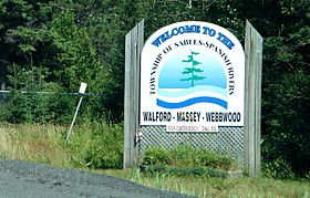
Sables-Spanish Rivers — Township Welcome sign along Highway 17 … Wikipedia
Sables-Spanish Rivers, Ontario — Infobox City official name = Township of Sables Spanish Rivers other name = native name = nickname = motto = imagesize = image caption = Highway 17 through Massey. flag size = image seal size = image shield = shield size = image blank emblem =… … Wikipedia
Spanish, Ontario — Infobox City official name = Town of Spanish other name = native name = nickname = motto = imagesize = image caption = flag size = image seal size = image shield = shield size = image blank emblem = blank emblem size = mapsize = map caption =… … Wikipedia
Rivière aux Sables (Ontario) — Ne doit pas être confondu avec Rivière aux Sables. Pour les articles homonymes, voir Rivière Au Sable. Rivière aux Sables Ontario (River aux Sables) … Wikipédia en Français
Spanish River (Huronsee) — Spanish River Mündung des Spanish River bei dem Ort SpanishVorlage:Infobox Fluss/KARTE fehlt Daten … Deutsch Wikipedia
Spanish River (Ontario) — The Spanish River in Northern Ontario, Canada flows 240 km in a southerly direction from its headwaters in Lake Biscotasi (west branch) and Duke Lake (east branch). Several other tributaries empty into the river, which passes through Agnew Lake… … Wikipedia
List of Ontario rivers — This is the list of rivers which are situated in and flow through Ontario. The watershed list includes tributaries as well.List of rivers arranged by watershedHudson Bay watershedIn order of drainage into Hudson Bay from west to east: *Echoing… … Wikipedia
Aux Sables River (Ontario) — The Aux Sables River is a river in Ontario which flows from Lac aux Sables and empties into the Spanish River near the town of Massey.At one time, this river was used to transport logs to sawmills downstream. It flows through Chutes Provincial… … Wikipedia
Sudbury District, Ontario — Infobox Settlement official name = Sudbury District other name = native name = nickname = settlement type = District motto = imagesize = image caption = Mattagami First Nation flag size = image seal size = image shield = shield size = city logo … Wikipedia
Parc provincial des Chutes — Les chutes vus du belvédère. Catégorie UICN II (parc national)[1] … Wikipédia en Français
 Canada
 Ontario


