Sabattus
- Sabattus
-
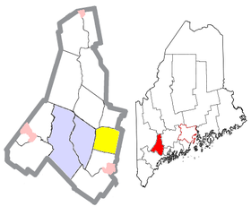
Sabattus est une ville située dans l’État américain du Maine, dans le comté de Androsscoggin.
Population
Selon le recensement de 2000, sa population est de 4 486 habitants.
Géographie
Cette section est vide,
insuffisamment détaillée ou incomplète.
Votre aide est la bienvenue !
Histoire
Cette section est vide,
insuffisamment détaillée ou incomplète.
Votre aide est la bienvenue !
Économie
Cette section est vide,
insuffisamment détaillée ou incomplète.
Votre aide est la bienvenue !
Culture
Cette section est vide,
insuffisamment détaillée ou incomplète.
Votre aide est la bienvenue !
Monuments et patrimoine
Cette section est vide,
insuffisamment détaillée ou incomplète.
Votre aide est la bienvenue !
Notes et références
Wikimedia Foundation.
2010.
Contenu soumis à la licence CC-BY-SA. Source : Article Sabattus de Wikipédia en français (auteurs)
Regardez d'autres dictionnaires:
Sabattus — Original name in latin Sabattus Name in other language State code US Continent/City America/New York longitude 44.1198 latitude 70.10755 altitude 77 Population 4694 Date 2006 01 17 … Cities with a population over 1000 database
Sabattus, Maine — Infobox Settlement official name = Sabattus, Maine settlement type = Town nickname = motto = imagesize = image caption = image mapsize = 250px map caption = Location of Sabattus (in yellow) in Androscoggin County and the state of Maine mapsize1 … Wikipedia
Dead River (Sabattus River) — Origin Maine Basin countries United States The Dead River is a 10.3 mile long (16.6 km)[1] tributary of Sabattus Pond in the U.S. state of Maine. Via the Sabattus River, the outflow of the po … Wikipedia
04280 — Sabattus, Me (Miscellaneous » ZIP Codes) … Abbreviations dictionary
Bahnstrecke Brunswick–Farmington — Brunswick ME–Farmington ME, Stand 1999[1] Gesellschaft: PAR Streckenlänge: 100,9 km Spurweite: 1435 mm (Normalspur) Gleise: 1 Legende … Deutsch Wikipedia
Historical U.S. Census Totals for Androscoggin County, Maine — This article shows U.S. Census totals for Androscoggin County, Maine, broken down by municipality, from 1900 to 2000.Like most areas of New England, Androscoggin County is (and has been at all times since well before the 20th century) entirely… … Wikipedia
National Register of Historic Places listings in Androscoggin County, Maine — Location of Androscoggin County in Maine This is a list of the National Register of Historic Places listings in Androscoggin County, Maine. This is intended to be a complete list of the properties and districts on the National Register of… … Wikipedia
Straßenbahn Augusta — Die Stadt Augusta im US Bundesstaat Maine hatte von 1890 bis 1932 einen Straßenbahnbetrieb. Inhaltsverzeichnis 1 Geschichte 1.1 Augusta, Hallowell and Gardiner Railroad 1.2 Augusta and Togus Railway … Deutsch Wikipedia
Androscoggin County, Maine — Location in the state of Maine … Wikipedia
Lewiston, Maine — Infobox Settlement official name = Lewiston, Maine settlement type = City imagesize = 250x200px image caption = The city of Lewiston to the right, with the twin city of Auburn on the left. The Androscoggin River separates the cities. image… … Wikipedia
 États-Unis
 Maine
Maine


