Petaluma
Contenu soumis à la licence CC-BY-SA. Source : Article Petaluma de Wikipédia en français (auteurs)
Regardez d'autres dictionnaires:
Petaluma — Petaluma … Deutsch Wikipedia
Petaluma — Petaluma, CA U.S. city in California Population (2000): 54548 Housing Units (2000): 20304 Land area (2000): 13.798892 sq. miles (35.738964 sq. km) Water area (2000): 0.104587 sq. miles (0.270879 sq. km) Total area (2000): 13.903479 sq. miles… … StarDict's U.S. Gazetteer Places
Petaluma, CA — U.S. city in California Population (2000): 54548 Housing Units (2000): 20304 Land area (2000): 13.798892 sq. miles (35.738964 sq. km) Water area (2000): 0.104587 sq. miles (0.270879 sq. km) Total area (2000): 13.903479 sq. miles (36.009843 sq.… … StarDict's U.S. Gazetteer Places
Petaluma — Petaluma, Stadt in Kalifornien, Grafschaft Sonoma, mit San Francisco in Dampferverbindung, am gleichnamigen schiffbaren Zufluß der San Pablobai, hat Industrie in Maschinen, Konserven etc., Handel mit Getreide und Obst und (1900) 3871 Einw … Meyers Großes Konversations-Lexikon
Petaluma — /pet l ooh meuh/, n. a city in W California, N of San Francisco. 33,834. * * * ▪ California, United States city, Sonoma county, western California, U.S. It lies at the head of navigation on the Petaluma River, 39 miles (63 km) north of San… … Universalium
Petaluma — Original name in latin Petaluma Name in other language Petaluma, Petluma, bytalwma, kalyfwrnya, pei ta lu ma, petaruma, ptalwma, kalyfrnya, Петалума, Петлума State code US Continent/City America/Los Angeles longitude 38.23242 latitude 122.63665… … Cities with a population over 1000 database
Petaluma Municipal Airport — sign outside Petaluma Municipal Airport IATA: none – ICAO: none – FAA LID: O69 Summary … Wikipedia
Petaluma Transit — is the public bus system that operates with the city of Petaluma, California, consisting of three bus lines: # Cherry Valley # McDowell, and # Ely.As of 2007, the fare was $1 per trip, and no evening, Sunday, or holiday service was… … Wikipedia
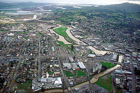
Petaluma, California — Infobox Settlement official name = City of Petaluma other name = native name = nickname = settlement type = City motto = imagesize = 250px image caption = Aerial view of Petaluma, Ca. View is to the southeast flag size = image seal size = image… … Wikipedia
Petaluma River — Geobox|River name = Petaluma River native name = other name = category = river etymology = Coast Miwok nickname = image caption = The river flowing through Petaluma. View is to the southeast. country = United States state = California region =… … Wikipedia

 États-Unis
 Californie


