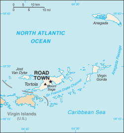
Passage d'Anegada
Contenu soumis à la licence CC-BY-SA. Source : Article Passage d'Anegada de Wikipédia en français (auteurs)
Regardez d'autres dictionnaires:
Anegada-Passage — östlich der Britischen Jungferninseln (rechts); im Norden die Insel Anegada (oben rechts) Verbindet Gewässer … Deutsch Wikipedia
Anegada Passage — östlich der Britischen Jungferninseln (rechts); im Norden die Insel Anegada (oben rechts) Die Anegada Passage ist eine Meerenge in der Karibik, die zwischen der Inselgruppe der Britischen Jungferninseln (im Westen) und der Insel Sombrero (im… … Deutsch Wikipedia
Anegada Passage — is a strait in the Caribbean, at coord|18.5|N|63.6666667|W|. It separates the British Virgin Islands and Sombrero Island of Anguilla … Wikipedia
Anegada Passage — ▪ channel, West Indies channel in the West Indies, connecting the Atlantic Ocean with the Caribbean Sea; it is 40 miles (65 km) wide and separates the British Virgin Islands (west) from the Leeward Islands (southeast). It has the greatest… … Universalium
Fosse d'Anegada — 18° N 65° W / 18, 65 … Wikipédia en Français
Projet:Maritime — Bienvenue sur la page du Projet du monde maritime ! Elle recense les participants aux projets, les ressources utiles, les règles et conventions habituelles, et permet la communication entre les participants … Wikipédia en Français
Virgin Islands — a group of islands in the West Indies, E of Puerto Rico: comprises the Virgin Islands of the United States and the British Virgin Islands. Abbr.: V.I., VI * * * Virgin Islands Introduction Virgin Islands Background: During the 17th century, the… … Universalium
Caribbean Sea — a part of the Atlantic Ocean bounded by Central America, the West Indies, and South America. ab. 750,000 sq. mi. (1,943,000 sq. km); greatest known depth 22,788 ft. (6946 m). Also called Caribbean. * * * Arm of the Atlantic Ocean. It covers about … Universalium
Geography of the United States Virgin Islands — See also: United States Virgin Islands U.S. Virgin Islands NASA NLT Landsat 7 (Visible Color) Satellite Image Location: Caribbean, islands 1,100 miles (1,770 km) southeast of Florida, 600 … Wikipedia
Dutch colonization of the Americas — European colonization of the Americas First colonization British colonization Courlandish colonization Danish colonization Dutch colonization … Wikipedia
 Royaume-Uni


 Portail de la Caraïbe
 Portail du monde maritime
